Posts

Showing posts from March, 2021

Developing Severe Weather Update

Image
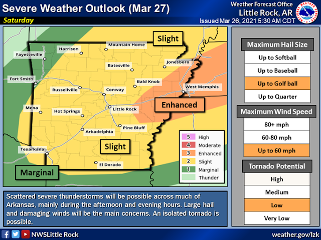
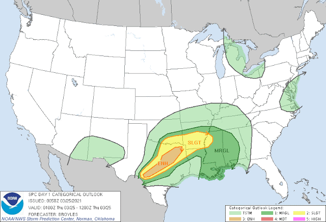
        Hey Everybody, Good Afternoon on this Lovely Saturday! It definitely feels great out there, it was a really nice Morning here in Little Rock. But unfortunately that Nice Weather will give way to some pretty mean storms that are expected to develop over the Next Several hours here across the State. Let's talk about it. So Storm Prediction Center in Norman Oklahoma has pushed the "Enhanced Risk" for Severe Weather further to the West to Include Central Sections of the State. This is an update from last night, which just included East Arkansas near the Mississippi Delta. Now the Mississippi Delta, and Points further to the West are Included. This does involve Little Rock, and most Surrounding Areas. Now it's worth Noting here that the Main Threats to look for will definitely be Damaging Straight Lined Winds, and Large Hail, but there is a Tornado Threat. The Tornado Threat is Fairly Low, but it's present due to the amount of Wind Energy associated with this S...
Severe Weather Update: Sketchy Weather Saturday

Image
        Hey Everybody how's it going!? I hope everybody is safe, enjoying this beautiful spring weather. Speaking of the Weather, we have more severe weather coming in. There is a Chance for more Severe Weather Saturday Night in the State associated with a Front moving through, there will be a lot of wind energy associated with this front. This system won't have a particularly high amount of Instability with it, but it will be a lot of Wind Shear (The Turning of Wind with Height). So even in a Night-time environment, Storms will still have the ability to develop and rapidly become severe.  Storm Prediction Center in Norman Oklahoma, has already issued a Slight Risk area for majority of the State with an Enhanced Risk for East Arkansas. An Enhanced Risk is an area of heightened concern within a general area.         The Main Threats here are Wind, and Hail, the Risk for Tornadoes is Definitely there, but I don't expect a Major Outbreak of...

Severe Weather Update: Mild To Wild

Image
        Hey Good Evening Everybody! I hope all is well, and everybody is staying safe. This will be the Second, and Third Severe Weather Setups of the Season here in the Mid-south for Spring Tornado Season 2021, it's not looking as potent, and intense as the Last one. But however, there are some definite Severe Weather possibilities with these next two setups.         Setup Number One is scheduled to arrive Later tonight, into Tomorrow morning. When I say "Tomorrow Morning" I mean between 3-8am in the morning, with this first round of storms, there's more of a Wind, and Hail Threat then a Tornado Threat due to the Timing of the system. I don't expect too Much in the way of Tornadoes, although some could be Possible. But Storm Prediction Center in Norman Oklahoma has outlined a Slight Risk for Severe Weather Overnight into the early morning hours Tomorrow for Southwest, and Central Arkansas.  As you can see Here, Slight Risk area for Seve...

⚠️SEVERE WEATHER UPDATE⚠️ Wicked Wednesday‼️

Image
        Hey Everybody, I hope all is great! Time to Change Gears here on the Blog, from Winter to Spring, from Snowmageddon to the ThunderDome! There is a Chance, our First Legit Chance for Severe Weather and Tornadoes here in Arkansas. There was somewhat of a chance this past Sunday (March 14th, 2021), but with evaporative cooling taking place over Arkansas, storms stayed Below Severe Limits with no Severe Storms. But however, this coming Storm System moving into Arkansas by Wednesday will be a lot more potent, and unstable. Due to the amount of Instability accompanied with this system, it has raised some obvious concerns for Severe Weather in the State. So Let's dig in.        While the Weather has been quite pleasant as we have shifted from Winter to Spring here in Arkansas, that comes at a price..... The Price we Pay is our Primary Storm Season, it's really starting to ramp up across Arkansas this week with one major chance at some pretty stro...