Severe Weather Update: Mild To Wild
Hey Good Evening Everybody! I hope all is well, and everybody is staying safe. This will be the Second, and Third Severe Weather Setups of the Season here in the Mid-south for Spring Tornado Season 2021, it's not looking as potent, and intense as the Last one. But however, there are some definite Severe Weather possibilities with these next two setups.
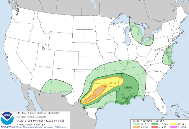
Setup Number One is scheduled to arrive Later tonight, into Tomorrow morning. When I say "Tomorrow Morning" I mean between 3-8am in the morning, with this first round of storms, there's more of a Wind, and Hail Threat then a Tornado Threat due to the Timing of the system. I don't expect too Much in the way of Tornadoes, although some could be Possible. But Storm Prediction Center in Norman Oklahoma has outlined a Slight Risk for Severe Weather Overnight into the early morning hours Tomorrow for Southwest, and Central Arkansas.
As you can see Here, Slight Risk area for Severe Weather for Southwest, Central, East, and Southeast Arkansas. The Primary concerns with this particular round of Storms is Wind, and Hail, a Tornado isn't out of the Question, but not Likely.
Now there's a Second round of Severe Weather that's expected to move through with the Front itself. This particular round is expected to move through in a Linear "Squall Line" type fashion moving from West to East across the State in the Afternoon/Evening Hours Tomorrow. Now due to the timing of this Particular Round, there is More of a Tornado Threat here because of the amount of Heat, and Instability that will be available to these Storms as the move through. The Entire State has some sort of potential for Severe, and Tornadic Storms, but the main focus will be In areas of East Central, and East Arkansas, because out there is where we expect to see the least amount of rain, and most amount of clear sunshine Skies, which creates more Instability for Storms to Develop.
This is a Graphic from the National Weather Service in North Little Rock, of the Risk areas issued by the Storm Prediction Center. You can see Central Areas will have a Slight Risk, but areas of East Arkansas will have an "Enhanced Risk" which is an elevated area of concern for Severe Weather and Tornadoes. There's a Moderate Risk for Severe Weather in Mississippi, now I would Not be Surprised if East Arkansas got added into that Moderate Risk area Tomorrow for Tornadoes. Because depending on how long the sun is out in East Arkansas Tomorrow, there may be a REAL chance for Scattered Tornadoes.
There will be a Tornado Watch issued for a Major part of the State Probably the Central and East One Half of The State as we move through tomorrow morning for the System coming in Tomorrow Evening. So be on the Look out for that, and Have a Plan in Place to take cover if one comes your way. I will NOT be out Chasing, I'm scheduled to have Surgery tomorrow so I will be down and out. But follow KARK/FOX 16 The Arkansas Storm Team for Pertinent Weather Information.


Comments
Post a Comment