Posts

Showing posts from April, 2015

To Update or Not To Update

       Hey everybody how's it goin! Im just doing this quick post here to clear the air on what I update and what I don't. Forecasting is very unique in the respect that everybody has their own way of doing it. You base a good forecast on what the models tell you,  what history tell you,  and what your own intelligence and guts tell you.  You take information for each of those variables and you summarize it into a general forecast of any given weather situation. Every forecast differ from Scientist to Scientist (Weatherman to Weathernan), it differs because everybody is different, everybody perceive things differently, and everybody think differently. So that being said, Sometimes When a system come through whether its winter,  or severe weather, if it does not look like something that will pose a DANGER or THREAT to human life, lots of times I will NOT update.  Especially here on the blog.  I might mention it on facebook and say hay, gr...

Severe Weather Update on Sunday Storms

Image
       Good Afternoon Everybody How's It Going!!! I hope everybody is having a Good and Safe Sunday afternoon. Well I'm doing this Update Shortly after 2:00pm, a Severe Thunderstorm Watch has been issued by the Storm Prediction Center over in Oklahoma. You remember in my update I told y'all they'd issue a Watch some time this afternoon. My expectations on the entire deal has NOT changed much overnight. I Still think the greatest threat for Severe Weather is over Central and East Arkansas. Storms will Initiate this afternoon over in West Arkansas, they will Likely go Severe warned due to a hail threat that they impose. Scattered Strong to Severe storms will start to develop here in Central Arkansas, with these storms the MAIN CONCERN is just Large Hail, and High Damaging Thunderstorm winds. I'm NOT EXPECTING a tornado outbreak of any kind. There could be a brief tornado warning or two, I cannot rule that out, this is Arkansas after all. But I'm Not expecting too ...

Sunday Spring Storms!!

Image
       Hey everybody!  How it going! This is the Arkansas Weather Hawk good for another Severe Weather Update. So the Weather has been BORING over the past Week and a half, Severe Weather wise not much has been going on. We have had Lots of Rain. But that's about it. That Will all change on Sunday. There is a Frontal Boundary setup to move through the state left to right. We all know the lyrics of this song right. Anything a Front comes through with moisture, and warm air aloft there lies a threat for Severe Weather, its a fact of life right. So with this system, I expect it to get going Sunday afternoon, Storms will initiate in Northwest, and West Arkansas as the Front advances towards our state. The severe threats are Hail, and High Damaging Thunderstorm Winds. Tornadoes can NEVER be ruled out. I cannot deny a Brief Spinup or two Somewhere in the State. As this Squall Line of Storms develop and start to move through the Highest tornado threat is with Storms th...

ATTENTION INCOMING SEVERE WEATHER!!!!

Image
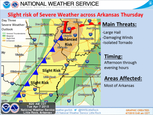
      Enjoy these Summertime Temperatures while they last, because the weather WILL NOT stay this way. There is a Slight Risk for Severe Weather set up over the next 36 hours. While there isa chance for Scattered Storms through Wednesday,  My concern comes in on Thursday. The Main Frontal Boundary will begin to push on into the State on Thursday. My Concern is Storms that Fire Up Thursday Evening Around West AND Central Arkansas along and ahead of that front.     When Storms fire up ahead of the Squall Line (Frontal Boundary ) they feed off of the Heat of the Ground and Instability within the air. Those (ISOLATED ) Thunderstorms have the BEST Potiential to Go Strong to Severe and Produce Tornadoes and cause Damage. The Tornado Theat is somewhat Marginal at best, but the Threat is THERE!!!    When Storms Gell into a Squall Line along the Cold Front they feed off of EACH OTHERS Entergy, so in this case Straight Line winds are more of a thre...

Staying Storm Ready

     Okay Now we are off into Storm Season here in Arkansas. Now as we get these frontal systems coming out of the west, and mixing with warm air from the south, these scattered Strong to Severe Storms start to form. Primarily in the Late Evening/Nighttime Hours. This year we've had a Few tornadoes, they have caused damage, Some of these storms randomly start to rotate and increase in intensity. Just have to be aware. The worst tornado we've had this year by far was in Tulsa Oklahoma a few weeks ago. Now even today (3:00PM Thursday the 2nd) there is a Chance for Severe Weather in the State. Hail & Wind are the Main concerns. But WHERE EVER YOU ARE IN THE STATE, You should have a Phone, And a NOAA Weather Radio. These two things will alert you when dangerous weather moves your way. If you have Smart Phones, Internet, or Computers, you  can Follow me, and your Local News Station on Social Media so that you have coverage, and you are well aware when dangerous weathe...