ATTENTION INCOMING SEVERE WEATHER!!!!
Enjoy these Summertime Temperatures while they last, because the weather WILL NOT stay this way. There is a Slight Risk for Severe Weather set up over the next 36 hours. While there isa chance for Scattered Storms through Wednesday, My concern comes in on Thursday. The Main Frontal Boundary will begin to push on into the State on Thursday. My Concern is Storms that Fire Up Thursday Evening Around West AND Central Arkansas along and ahead of that front.
When Storms fire up ahead of the Squall Line (Frontal Boundary ) they feed off of the Heat of the Ground and Instability within the air. Those (ISOLATED ) Thunderstorms have the BEST Potiential to Go Strong to Severe and Produce Tornadoes and cause Damage. The Tornado Theat is somewhat Marginal at best, but the Threat is THERE!!!
When Storms Gell into a Squall Line along the Cold Front they feed off of EACH OTHERS Entergy, so in this case Straight Line winds are more of a threat than tornadoes. HOWEVER, With all of the Commotion and Wind Energy within Squall Lines themselves, it is very possible for little kinks within the squall line to form, and little Spinup tornadoes can come out of that. ALL OF THIS is within the realm of possibilities on Thursday, Thursday Evening, and Thursday Night! Below I will Post outlined areas that will be in concern (The Entire State).
Good Thing about this forecast is that it's being made DAYS in ADVANCE of this Storm System, thats plenty of time to get ready for Severe Weather.
 Now this Map is Courtesy of the Storm Prediction Center In Norman Oklahoma for putting this together, as you can see a SLIGHT Risk for Severe Weather is in Place for the Entire State, this is Valid Thursday Afternoon - Night for Severe Weather and Tornadoes. This MIGHT GET UPGRADED as we get closer to Thursday. On Thursday at some point, I do expect for a Tornado Watch to be Issued for a Part of Arkansas due to a Possibility of Tornadoes.
I will not be actively Chasing on Thursday, But if a Tornado Threatens the Metro or any Surrounding areas, I will activate and deploy. I will be Chase Ready and Actively Watching for ANYTHING that posses a threat to Safety.
If you Haven't yet, make sure you follow me on Social Media
TheArkansas WeatherHawk - Facebook
@OmarrWilson - Twitter
+The Arkansas Weather Hawk - Google Plus
KARK CHANNEL 4 - FOX 16 News
I Am The Arkansas Weather Hawk
When Storms fire up ahead of the Squall Line (Frontal Boundary ) they feed off of the Heat of the Ground and Instability within the air. Those (ISOLATED ) Thunderstorms have the BEST Potiential to Go Strong to Severe and Produce Tornadoes and cause Damage. The Tornado Theat is somewhat Marginal at best, but the Threat is THERE!!!
When Storms Gell into a Squall Line along the Cold Front they feed off of EACH OTHERS Entergy, so in this case Straight Line winds are more of a threat than tornadoes. HOWEVER, With all of the Commotion and Wind Energy within Squall Lines themselves, it is very possible for little kinks within the squall line to form, and little Spinup tornadoes can come out of that. ALL OF THIS is within the realm of possibilities on Thursday, Thursday Evening, and Thursday Night! Below I will Post outlined areas that will be in concern (The Entire State).
Good Thing about this forecast is that it's being made DAYS in ADVANCE of this Storm System, thats plenty of time to get ready for Severe Weather.
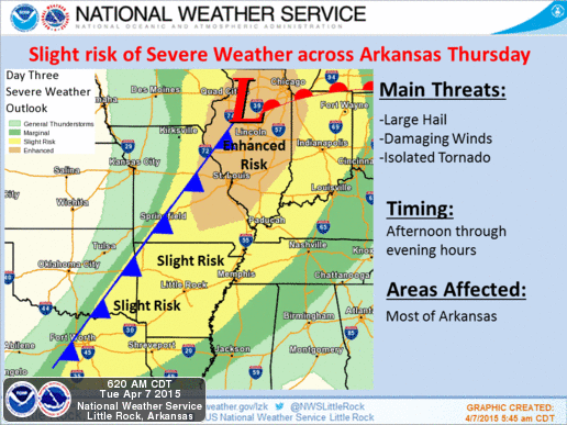
Now this First Map here is courtesy of the National Weather Service In North Little Rock for putting this together. It shows basically everything I said, Squall line with the Front itself from Left to Right Across the State, Strong Storms, hail, High Winds, and Tornadoes are all a Threat. Thursday Afternoon - Night for the Entire State.
I will not be actively Chasing on Thursday, But if a Tornado Threatens the Metro or any Surrounding areas, I will activate and deploy. I will be Chase Ready and Actively Watching for ANYTHING that posses a threat to Safety.
If you Haven't yet, make sure you follow me on Social Media
TheArkansas WeatherHawk - Facebook
@OmarrWilson - Twitter
+The Arkansas Weather Hawk - Google Plus
KARK CHANNEL 4 - FOX 16 News
I Am The Arkansas Weather Hawk
Comments
Post a Comment