SEVERE WEATHER UPDATE /5/27/17: Memorial Weekend Trouble
Hey Everybody, how's it going! I'm sorry to do this update so Late in the Program, but this Update Really needed to be done. It's hard sometimes juggling a Full-time Job, career, and Business all at the same time! Weather is QUIET when I have time to dedicate to it. But when I get busy, Weather wants to act up! Isn't that something!? But anyways, what's going to happen tonight, amd tomorrow? Tornadoes? Storms? Wind? Hail? Finger of God, or what??? That's why everybody's here, so let's get into it!
This past week I've been watching this system, at first it was looking like it would approach us from the East, which would give it the Speed, and Directional force it needs to be a REAL TROUBLE MAKER! But it has become clear to me that this system is dropping South, from the North. While that will still give us a substantial Severe Weather Threat, not as big of a threat as it would if we was rocking with the other scenario.
Now what do I expect? I'm thinking this Squall Line that's dropping South into the state will bring some Very strong Winds, very Powerful Thunderstorms will be moving through. They will bring strong winds, hail, and lightning, LOT'S OF IT!!! There is a Chance for Tornadoes, it's a Marginal Chance! If you had to ask what scale of chance, I'd say a Medium threat for Tornadoes. That's not to say we will get any, bc I'm more worried about Severe Winds than Tornadoes at this point.
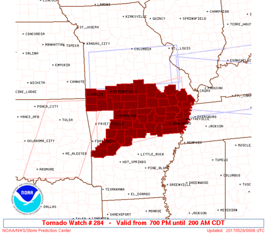
Next question is WHERE? NORTH ARKANSAS has the Best Chance for Tornadoes, and that chance stands RIGHT NOW! There is Currently (7:25pm 5/27/2017) a Tornado Watch in effect for North Arkansas, and a New one now for North Central Arkansas. It will be extended further south later into the night as the system moves in. But It is evening time, right now is when I'd look for possible Tornado Development. There is still a chance after midnight for Central Arkansas, but not as high of a chance! I expect this to drop south and move into Central parts of the State sometime after Midnight - approx 2am tonight! There will Likely be a Tornado Watch in effect for Central Arkansas at that time!

This past week I've been watching this system, at first it was looking like it would approach us from the East, which would give it the Speed, and Directional force it needs to be a REAL TROUBLE MAKER! But it has become clear to me that this system is dropping South, from the North. While that will still give us a substantial Severe Weather Threat, not as big of a threat as it would if we was rocking with the other scenario.
Now what do I expect? I'm thinking this Squall Line that's dropping South into the state will bring some Very strong Winds, very Powerful Thunderstorms will be moving through. They will bring strong winds, hail, and lightning, LOT'S OF IT!!! There is a Chance for Tornadoes, it's a Marginal Chance! If you had to ask what scale of chance, I'd say a Medium threat for Tornadoes. That's not to say we will get any, bc I'm more worried about Severe Winds than Tornadoes at this point.
Next question is WHERE? NORTH ARKANSAS has the Best Chance for Tornadoes, and that chance stands RIGHT NOW! There is Currently (7:25pm 5/27/2017) a Tornado Watch in effect for North Arkansas, and a New one now for North Central Arkansas. It will be extended further south later into the night as the system moves in. But It is evening time, right now is when I'd look for possible Tornado Development. There is still a chance after midnight for Central Arkansas, but not as high of a chance! I expect this to drop south and move into Central parts of the State sometime after Midnight - approx 2am tonight! There will Likely be a Tornado Watch in effect for Central Arkansas at that time!

Here is a graphic of the newest Tornado Watch in effect for North, and North Central Arkansas until 2AM CDT.
Here's a Forecast Courtesy of the National Weather Service in North Little Rock. Later tonight into tomorrow morning there is a chance for the Storms to Organize as the Front drops south. If they do organize they will have to be closely watched for Tornadic Development. So if you Live in Central Arkansas, the time to watch these storms is Early Morning Sunday.
If you guys have ANY QUESTIONS, Please Feel free to ask, I promise I will get them answered as SOON as I possibly can! Thanks for Coming here To the Weather Hawk's Blog, and STAY SAFE!!!!!
Follow Me On Social Media
@Omarrian Wilson - Facebook
@OmarrWilson - Twitter
@The Arkansas Weather Hawk - Google +
When a tornado warning is issued, approximately how much time do you have to get in your safe spot? The
ReplyDeleteIt depends, sometimes a matter of seconds, sometimes as much as 30 minutes. It depends on how close the storm is to your particular location. It also depends on where the storm is moving relative to your location. If you're at point A, and the storm is north of you moving northeast, then your your county is in the warning, but you are safe. So It really just depends on where you are relative to the Tornado. If a Tornado warning is out for your county or town, and your physical Location is In the direct path, then You usually have a matter of minutes to take cover. But again, it depends on how close the storm is to you. If it goes warned, and it's right over you, then you have no time. And if a tornado touches down, you're dead.......
Delete