Hey Everybody, How Y'all Doing!? So Tonight and Into tomorrow Morning, there's a chance for some mixture of Wintery Precipitation in North, West, and West Central Arkansas. I do not however think that anywhere in central Arkansas will have a sufficient chance for any type of Winter Weather. I do not think the Temperatures will fall deep enough into the 30s for winter weather to happen here in central sections of the state. But in the higher elevations in North Arkansas, and areas of West and West Central Arkansas could see accumulating snow.

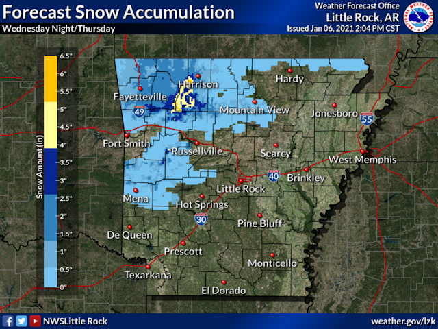
This is the Accumulation Map of the National Weather Service in North Little Rock. Their forecast tends to line up perfectly with my expectations, as well as the Model Guidance. The Cooler air will be aloft more so than on the surface, so higher elevations in the Mountains will have more Accumulating Snow than anybody else. But even the lower areas of West, and West Central Arkansas will have a chance at Accumulating Snow due to the projected movement of the cooler air.
This is the latest run of the NAM (North American Model), valid between the hours of 3am and 6am Thursday Morning, as you can see here the NAM is pretty consistent, with Snow or Some type of frozen precips, which is where the Accumulation predictions are coming from.
This is the NAM Between the Hours of 6am and 9am Thursday Morning, even between 3am, and 9am in the morning, this particular model still projects accumulating snowfall across Western Sections of the state.
Now, I'm not necessarily buying this from the NAM, but this does show at least the possibility of some type of Wintery changeover in Central Arkansas as this all exists the state by Thursday Afternoon.
DO NOT TAKE THESE WEATHER MODELS TO HEART!!! This is all perspective, sometimes these models don't play out exactly like they're projected to. So come tomorrow morning, this might look a little bit different on Radar.
Now there is another Weather Maker coming in on Sunday Night/Monday Morning that will be tracking to the South of Arkansas, but there is a chance that Southern Arkansas get some type of Wintery Precipitation. How Much, and exactly where is still in the air. The EURO (European Weather Model) is pretty aggressive with Snowfall Coverage, the GFS (Global Forecasting System) is not necessarily aggressive with the Coverage, but it does bring in chances nevertheless.


Comments
Post a Comment