**SEVERE WEATHER UPDATE 02/26/2017**
Hey everybody, how's it going! It's been a while since my last post here on the blog. As you all know when the weather is quiet and nice, I tend to stay away from the blog. I try to only use it for the really serious stuff. So, with that being said, It's looking like we have a particularly interesting setup coming in over the next few days. A frontal boundary will move over the state tonight, and tomorrow morning, that will allow waves of low pressure to move over the state. Now, this will set the stage for some severe weather. So, let's get right into things!
Okay, so we didn't have much of a winter! THAT SUCKS! I was hoping for some good shots at some snow storms and stuff. I mean granted, OUR SCIENTIFIC Winter has not ended yet. But there's no hope in the future for snow! LOL! But it's now time for METEOROLOGIST, and the public alike to shift our focus from the DEAD Winter that we had on to Tornadoes and Severe Weather! WITH THAT BEING SAID, This is Severe Weather Awareness Week (February 26th - March 4th). If you DO NOT have a NOAA Weather Radio, I strongly advise EVERYBODY to pick one up. If Tornadoes, or deadly weather moves through at night while you're sleeping, the TV and the Tornado Sirens WILL NOT Wake you up. That Weather Radio is programmed for your county so if stuff go down while you're sleep it will sound off, and they are Loud!
Now on to what's expected this week. Monday there is a chance for storms, but I don't expect them to be Severe. They could be Strong at times, but the Primary concern is Tuesday Evening, Night, and into Wednesday Morning. A wave of energy with storms will pass through Monday, but a Stronger wave on Tuesday. I expect this to be in the form of a Squall Line that will move from left to right across the state. NOW, at this time, My PRIMARY CONCERN is HAIL, and Damaging Thunderstorm Winds.... There is a Threat for Tornadoes, but we'll get to that! There will be turbulent winds aloft, which will give us a prominent Hail threat. There will be a strong wind field with this system so the threat for damaging winds will be there. NOW FOR THE THREAT OF TORNADOES.........
The threat for Tornadoes is LOW, but based SOLELY off of the Instability Measures alone, Tornadoes are a possibility. The Threat is relatively Low due to the time of day this system is expected to move through, overnight there's not a lot of ground heating left over from the sun at the surface, so the threat is lessened. But there is a moderate level of instability that will be present, which could allow for the development of Tornadoes. Which is why at some point Tuesday Evening I FULLY expect for a Tornado Watch to be issued for certain parts of Arkansas.
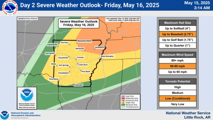

Here's a map Courtesy of The Storm Prediction Center in Norman, Oklahoma. This just show's the graphics of their Slight-Enhanced Risk for Severe Weather on Tuesday.
Now again, the Main threat is for HAIL, AND WIND. Tornadoes are a threat, but at THIS TIME, not a major or high threat. It just a Low probability for Isolated Tornadoes. This Is Subject to change, I'll do new updates if anything does. Be sure to Follow me on Social Media!
Follow Me On Social Media
Omarrian Wilson - Facebook
@OmarrWilson - Twitter
The Arkansas Weather Hawk - Google Plus
Okay, so we didn't have much of a winter! THAT SUCKS! I was hoping for some good shots at some snow storms and stuff. I mean granted, OUR SCIENTIFIC Winter has not ended yet. But there's no hope in the future for snow! LOL! But it's now time for METEOROLOGIST, and the public alike to shift our focus from the DEAD Winter that we had on to Tornadoes and Severe Weather! WITH THAT BEING SAID, This is Severe Weather Awareness Week (February 26th - March 4th). If you DO NOT have a NOAA Weather Radio, I strongly advise EVERYBODY to pick one up. If Tornadoes, or deadly weather moves through at night while you're sleeping, the TV and the Tornado Sirens WILL NOT Wake you up. That Weather Radio is programmed for your county so if stuff go down while you're sleep it will sound off, and they are Loud!
Now on to what's expected this week. Monday there is a chance for storms, but I don't expect them to be Severe. They could be Strong at times, but the Primary concern is Tuesday Evening, Night, and into Wednesday Morning. A wave of energy with storms will pass through Monday, but a Stronger wave on Tuesday. I expect this to be in the form of a Squall Line that will move from left to right across the state. NOW, at this time, My PRIMARY CONCERN is HAIL, and Damaging Thunderstorm Winds.... There is a Threat for Tornadoes, but we'll get to that! There will be turbulent winds aloft, which will give us a prominent Hail threat. There will be a strong wind field with this system so the threat for damaging winds will be there. NOW FOR THE THREAT OF TORNADOES.........
The threat for Tornadoes is LOW, but based SOLELY off of the Instability Measures alone, Tornadoes are a possibility. The Threat is relatively Low due to the time of day this system is expected to move through, overnight there's not a lot of ground heating left over from the sun at the surface, so the threat is lessened. But there is a moderate level of instability that will be present, which could allow for the development of Tornadoes. Which is why at some point Tuesday Evening I FULLY expect for a Tornado Watch to be issued for certain parts of Arkansas.
These Graphics is Courtesy of The National Weather Service in North Little Rock. The Storm Prediction Center in Norman, Oklahoma has went ahead and placed a Large part of Arkansas from West Central, to Central, West, and North West Arkansas under an "Enhanced Risk" for Severe Weather. This Does include Little Rock and all Surrounding areas. An "Enhanced Risk" basically means "Area Of Concern Within an Area of Concern", so to Simplify that, the ENTIRE State Has a Risk for some type of severe weather. But there is a certain area of the state that I'm more concerned about than the rest.
Here's a map Courtesy of The Storm Prediction Center in Norman, Oklahoma. This just show's the graphics of their Slight-Enhanced Risk for Severe Weather on Tuesday.
Now again, the Main threat is for HAIL, AND WIND. Tornadoes are a threat, but at THIS TIME, not a major or high threat. It just a Low probability for Isolated Tornadoes. This Is Subject to change, I'll do new updates if anything does. Be sure to Follow me on Social Media!
Follow Me On Social Media
Omarrian Wilson - Facebook
@OmarrWilson - Twitter
The Arkansas Weather Hawk - Google Plus


Thanks Omarr! Stay safe!
ReplyDeleteWill do! And same to you! I appreciate you for coming to the blog!
Delete