Posts

Showing posts from January, 2018

From Snow To Spring? Welcome To Arkansas!

Image
       Hey everybody how's it going on this bitterly cold morning.?! I hope everybody got through the first official Winter 2017/2018 Snow Storm for Arkansas. I can't call it really the "first" because Friday areas in East Arkansas got upwards of about 3" of Snow in some spots. But this storm was a bit more expansive then the last. The last storm had a very narrow band of snow (it was very heavily forecasted by myself, and other forecasters), this storm here was also very heavily forecasted by a lot of meteorologist. Now I must say right here and now, that the Arkansas Department of Transportation really rocked out on those freeways man, those guys got out there as early as Monday Morning pre-treating the highways in preparation for the storm, they really rocked! I'm very proud of them for braving the weather prepping the roads, they did a good job. Now I also must say, we (Weather Forecasters) really hit it with this storm, it didn't bring especially min...

DEVELOPING: Winter Weather Update 1/15/2018

Image
        GoodMorning Everybody!!!  Yesterday morning I gave a weather update, regarding a developing weather system bringing us our next chance of snow this week. Well new model guidance has come in, so now I have a cleaner picture of what will happen, and some possible accumulations. Let's jump to this!       Now, What to expect? Well let me start by saying first off, I DO NOT EXPECT A SNOW STORM...... I don't expect in no way, shape, or form a widespread snow storm, or blizzard. This will be a frontal disturbance that will bring a limited amount a moisture with it. Yes, this will be enough to give us problems, but not enough to call it a "Storm". So now that we got that squared away, how much snow are we looking at?  Well this particular front comes from the north, and typically we don't get much out of systems like this, but I have some solid totals out of the models. See Pictures below: Now this is the 06z run of the GFS (Global Forec...

Very Active Winter Weather Pattern!!!

Image
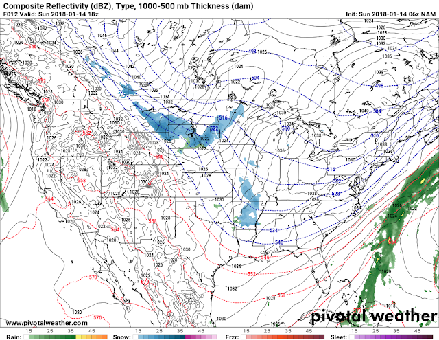
        GoodMorning Everybody, how's it going?! I just finished pouring over the latest run of model data, and I have to say, I'm not really all that impressed by it. As of right now, Sunday, January 14th, 2018 @0700am there are light snow showers out in North Central Arkansas, gotten several reports of Ice, and Snow covering the roads in Russelville, Clarksville. I-40 has Ice and Snow patches up in that area of West and North Central Arkansas. So if you're out, or have to go out up there, BEWARE!.        Now, as far as Central Arkansas what's to be expected, and what's going on. There is a chance for Snow within the next 36 hours..  The questions here are how often and when? Well if you look at the latest run of the NAM (North American Weather Model), then there's a chance today, and somewhat of a chance tomorrow. There is a disturbance coming out of the north that's riding the "coat tails" of the front that moved through about 2 days ago. ...

WINTER WEATHER UPDATE: Weekend Winter Weather

Image
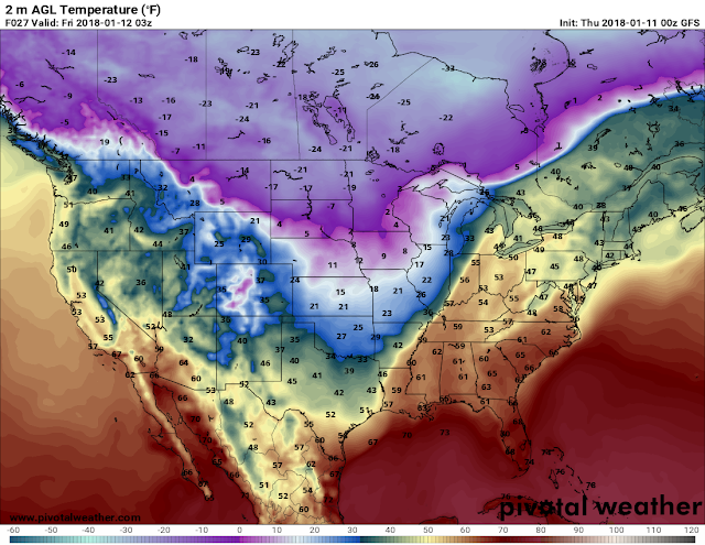
      Hey everybody, how's it going today!?  I know, I said on Social Media yesterday that I was going to do a Winter Weather Update, but the joys of having 2 jobs, and a business...... But I'm sort of glad I didn't do that update because it would've been contradicting the one I'm making tonight!! So, about this weekend stuff, what's going to happen? Let's get into it.      Okay as far as temperatures go, what are we looking at? Well a dip in the Jet Stream will move through the Central US, along the leading ege of that will be a cold front, that particular cold front will bring some very cold bone chilling Arctic Air with it. Now I'm not talking about SINGLE DIGITS type cold, I'm talking about mostly 20s maybe some high Teens, but highs will be in the deep 30s. So it won't be nothing like the New Years Chill we had. But it will be cold none the less. Now this air will start tanking South through the great plain states on Thursday, and Thursday ...