WINTER WEATHER UPDATE: Weekend Winter Weather
Hey everybody, how's it going today!? I know, I said on Social Media yesterday that I was going to do a Winter Weather Update, but the joys of having 2 jobs, and a business...... But I'm sort of glad I didn't do that update because it would've been contradicting the one I'm making tonight!! So, about this weekend stuff, what's going to happen? Let's get into it.
Okay as far as temperatures go, what are we looking at? Well a dip in the Jet Stream will move through the Central US, along the leading ege of that will be a cold front, that particular cold front will bring some very cold bone chilling Arctic Air with it. Now I'm not talking about SINGLE DIGITS type cold, I'm talking about mostly 20s maybe some high Teens, but highs will be in the deep 30s. So it won't be nothing like the New Years Chill we had. But it will be cold none the less. Now this air will start tanking South through the great plain states on Thursday, and Thursday Night. I don't expect the cold air to get here until EARLY FridaI morning. Now there is a disturbance with moisture coming with it! More on that in a second, but the GFS (Global Forecasting System), and the NAM (North American Model) are somewhat starting to line up with each other. Which is why I said If I would've made an update yesterday, it would've been different than this information here which is why I'm glad I waited!!! See pictures Below:


Okay as far as temperatures go, what are we looking at? Well a dip in the Jet Stream will move through the Central US, along the leading ege of that will be a cold front, that particular cold front will bring some very cold bone chilling Arctic Air with it. Now I'm not talking about SINGLE DIGITS type cold, I'm talking about mostly 20s maybe some high Teens, but highs will be in the deep 30s. So it won't be nothing like the New Years Chill we had. But it will be cold none the less. Now this air will start tanking South through the great plain states on Thursday, and Thursday Night. I don't expect the cold air to get here until EARLY FridaI morning. Now there is a disturbance with moisture coming with it! More on that in a second, but the GFS (Global Forecasting System), and the NAM (North American Model) are somewhat starting to line up with each other. Which is why I said If I would've made an update yesterday, it would've been different than this information here which is why I'm glad I waited!!! See pictures Below:

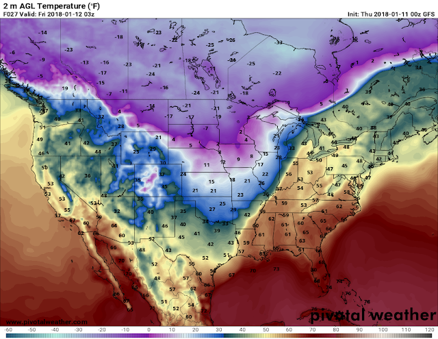
Okay this is the 00z (Midnight Run) of the GFS (Global Forecasting System), this is valid Friday morning in between the hours of 12midnight and 3am. You can clearly see where the frontal is located it's a very sharp drop in temperatures. So around 10pm Thursday night into Midnight Friday morning it will be semi-mild, but come 3am it will feel COMPLETELY DIFFERENT!

Now this is the GFS valid from 3am - 6am Friday morning. It's already forecasted by this particular model to be near freezing. So by Friday Morning the Front it here.!

Now this is the 00z run of the NAM (North American Model),and as you can see it's saying the exact same thing plus or minus a few degrees. Now when we're talking Freezing Rain, Sleet, and Snow, a few degrees is VITAL....
Now, with all of that being said, MOISTURE; What's the moisture looking like? Rain, Sleet, or Snow, or Ice? What's up? .......... Well as it sits right now, at this particular time, I see a possibility for EVERYTHING! I see a chance for rain to start, then I see a changeover as the cold air moves in, then I see a complete switch to all Snow being possible at the tale end of all of this......... That scenario is on the table. Look, the moisture gets here BEFORE the cold air does, that's almost an understood given at this point. So timing wise, I'm saying late Thursday Night, maybe 9-10pm the rain starts. Cold air isn't slated to get here until the next morning..... See Pictures below:

Now this is the Precipitation map of the 00z GFS, it shows rain between the hours of 10pm Thursday and Midnight on Friday. I do not think rain coverage will be that expansive, you really have to take these models with a grain of salt, but it should be raining in spots within that timeframe.

Now this is between the hours of 12midnight Friday morning and 3am. You can see the GFS is really ramped up with some moderate rain totals in East Arkansas, with a changeover up north.

Now this is when something interesting happens, the GFS is hinting at a changeover down here as far south as Central Arkansas on the back end of all of this, as it moves into East Arkansas early Friday Morning. How likely is this to Verify? I'd say 40/60 chance.....

Now the GFS actually continues the onslot of Sleet even later into to Friday Morning here in Central and East Arkansas. I have no faith in this to be honest. I do believe that this will move MUCH FASTER, but the possibility for the precipitation to be in those areas are there.

Now I must say, NO WAY the moisture last this deep into Friday morning, but this shows a chance for snow.... This map is valid from 9am-12noon Friday morning. I think this will be gone before 9 to be honest, but the chance for a changeover to all snow on the back end of all of this in East Arkansas is there!

Now this is the 00z run of the NAM (North American Model) it shows the rain in Central, South, and East Arkansas. But the NAM isn't as over the top with it, and the NAM shows it coming in a little bit Later Friday Morning by 3am.

The NAM keeps the Vast Majority of the frozen stuff in EAST Arkansas only, and this is between the hours of 3am and 6am.

The NAM has this stuff gone and out of here before 9am Friday Morning which lines up more with what I expect.
Now given all of this information, what do I think of this? Well at this point I'm thinking that this moisture will setup around midnight or so, and it will be all plain Jain rain until about 3am. The cold air sinks in, and we start seeing a changeover up North. How far south the Ice gets all depends on how quickly the cold air sets up. I do think we will see a changeover in spots here in Central Arkansas, not enough to cause problems though. But as far as NORTH, AND EAST ARKANSAS (Areas from Mountain Home, to Jonesboro, to Blytheville) will see some decent totals of SLEET AND FREEZING RAIN..... Now East Arkansas (Along I-40 from Hazen on over to the border) I think you guys will see more sleet than anything else. Areas in the Delta like Phillips, Monroe, and St. Francis counties will see decent chances for ICE on Friday Morning...... This is gone before 10am Friday morning. If you live in those areas I named, EXPECT TRAVEL DELAYS, AND EXPECT HAZARDOUS DRIVING CONDITIONS..... Now it's only Wednesday, this can still change so stay tuned for any future updates. Thank you all for coming here to the Arkansas Weather Hawk's Blog!
Follow Me on Social Media
@Omarrian Wilson - Facebook
@OmarrWilson - Twitter
@The Arkansas Weather Hawk - Google Plus
@thearkansas_weatherhawk - Instagram


Comments
Post a Comment