Very Active Winter Weather Pattern!!!
GoodMorning Everybody, how's it going?! I just finished pouring over the latest run of model data, and I have to say, I'm not really all that impressed by it. As of right now, Sunday, January 14th, 2018 @0700am there are light snow showers out in North Central Arkansas, gotten several reports of Ice, and Snow covering the roads in Russelville, Clarksville. I-40 has Ice and Snow patches up in that area of West and North Central Arkansas. So if you're out, or have to go out up there, BEWARE!.
Now, as far as Central Arkansas what's to be expected, and what's going on. There is a chance for Snow within the next 36 hours.. The questions here are how often and when? Well if you look at the latest run of the NAM (North American Weather Model), then there's a chance today, and somewhat of a chance tomorrow. There is a disturbance coming out of the north that's riding the "coat tails" of the front that moved through about 2 days ago. Now the Temperatures will be below freezing for MOST of the day, the high might get up to freezing at best. So of there is any moisture, it will be frozen! See pictures below:


Now, as far as Central Arkansas what's to be expected, and what's going on. There is a chance for Snow within the next 36 hours.. The questions here are how often and when? Well if you look at the latest run of the NAM (North American Weather Model), then there's a chance today, and somewhat of a chance tomorrow. There is a disturbance coming out of the north that's riding the "coat tails" of the front that moved through about 2 days ago. Now the Temperatures will be below freezing for MOST of the day, the high might get up to freezing at best. So of there is any moisture, it will be frozen! See pictures below:

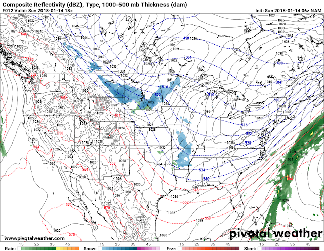
This is the latest 06z run of the NAM. The NAM shows a wave of light moisture, in this case snow/flurries for much of the state later on this evening. However, I don't know if I exactly believe it or not. IF ANYTHING does fall, I can tell you that it will be LIGHT and SHOULDN'T cause any travel issues, but it is a Sunday, nobody has anywhere to go.

Now the NAM does show another wave of moisture tomorrow morning North of Arkansas making it's way towards the mid south.

The NAM does Not however show much moisture Monday night, and into Tuesday. **This is Subject to Change** but at this time, due to this ONE RUN OF THIS ONE MODEL, I don't see much!

This is the 06z Run of the GFS (Global Forecasting System), and this frame is valid Tuesday morning, and it shows a little bit more than the NAM with a Snow band setting up mainly in South Arkansas and moving in a Southerly direction. Obviously it's more than the NAM shows, but I don't have much merit in the GFS either.
Now, as far as Accumulations are concerned, I do not think there will be much that will come out of these waves of moisture. These disturbances don't exactly bring an abundance of moisture with them, but there is a chance for something. Now my opinion is there is a 50/50 chance between either the GFS or the NAM to verify. I do believe that there will be a wider area of precipitation on Tuesday Morning as the Disturbance moves through the state. If that verify, then that will give certain areas of central and south Arkansas 1-2" of Snow on Tuesday Morning. The GFS was saying much more snow, than I'm inclined to believe, the NAM was saying 1.2-1.5inches of snow in South Arkansas by Tuesday morning, I can believe that. If there are ANY further changes or developments I will be back with further updates in the forecast because this CAN CHANGE over the next 6-12 hours!! Thanks for coming to the blog Everybody, and GoodMorning!!
Follow Me On Social Media
@Omarrian Wilson - Facebook
@OmarrWilson - Twitter
@The Arkansas Weather Hawk - Google Plus
@thearkansas_weatherhawk - Instagram


Comments
Post a Comment