**SEVERE WEATHER UPDATE** Frightening Friday Weather Coming
Hey Everybody, how's it going on this Thursday night. Unfortunately a harsh reality of spring in Arkansas is Severe and potentially Deadly weather. Tomorrow is one of those days where we will definitely have some of that weather. Now this will be a very typical spring severe weather set up for Arkansas. We will have a front moving in with a certain amount of instability which will be sufficient enough for Supercell thunderstorms to develop, and rotate, and produce tornadoes. Now down to the meat and potatoes.........
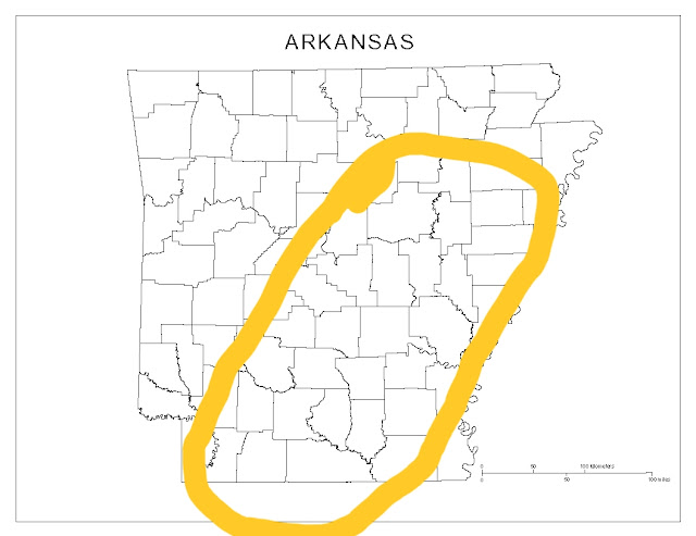
What everyone wants to know is what are the risk for tomorrow.? Well at this point EVERYTHING is a risk, Wind, Hail, Tornadoes the whole 9! I think the area with the Highest chance of Severe Weather is this outlined area below:
What everyone wants to know is what are the risk for tomorrow.? Well at this point EVERYTHING is a risk, Wind, Hail, Tornadoes the whole 9! I think the area with the Highest chance of Severe Weather is this outlined area below:

If you live ANYWHERE in that outlined area; I expect Severe Supercell Thunderstorms, I expect storms with Strong Winds, Large hail, and large violent Tornadoes ARE POSSIBLE in that outlined area!
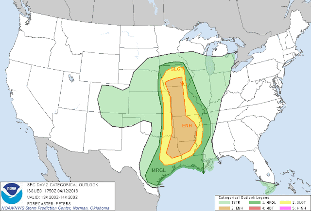
This is the risk outlook map courtesy of the Storm Prediction Center in Norman Oklahoma, they have a majority of the state under an "ENHANCED Threat" for severe weather, enhanced risk means elevated area of concern within an area of concern (Area of Paranoia, if you will)... I FULLY EXPECT the Severe Weather Risk to be upgraded from "Enhanced" to "Moderate" due to the fact that Tornadoes, and potentially Violent ones are expected. At some point tomorrow afternoon a TORNADO WATCH will be issued for a Large Part of the State.
Now as Far as TIMING..... It breaks down like this; 12-1pm - Storms will initiate in West Oklahoma along and ahead of the front, precipitation will be scattered at this time. 2-4pm - Storms will move into/develop in a Scattered manner in West Arkansas (Some of them will be severe once organized). 5-7pm - Storms wil move out of West and into Central Arkansas, any ORGANIZED Supercell thunderstorms at this point will pose a serious threat of Tornadoes, and all other modes of Severe Weather. 7-10pm - Storms will move into/through East Arkansas and will lose intensity as they move further East.
People I STRONGLY Urge you, as you're getting off of work, and out of school, PLEASE have a way to receive Severe Weather Warnings! Not all Tornadoes you will see, even in the daytime they can be INVISIBLE, if you drive into it, that's Russian Roulette with your life! I will be SPAMMING all Modes of Social Media with updates as this developing situation unfolds. If you have ANY Questions or Concerns PLEASE, Do NOT Hesitate to ask!
Follow Me On Social Media:
@Omarrian Wilson - Facebook
@OmarrWilson - Twitter
@The Arkansas Weather Hawk - Google Plus
@thearkansas_weatherhawk - Instagram


Comments
Post a Comment