Posts

MidWeek Trouble

      Okay so Tuesday there is a chance for Scattered Strong to Severe Storms in North/Northwest Arkansas. Wind, Lightning, and Hail is the main threats. There is a SLIGHT risk for Severe Weather Associated with this System as there could be Some Scattered Severe Thunderstorm Warnings issued by the NWS. For Us in the Rest of the State, the real threat comes from The Cold front itself which is slated to move through on Wednesday. Cold Fronts in spring are accompanied by SQUALL LINES. In this type of setup, it will be a Broken Line of thunderstorms Probably, Damaging Straight Lined Winds, Hail, Heavy Rain, and Deadly Lightning will be some things to watch out for. At this time I DO NOT think Tornadoes will be a Concern. It is Arkansas Weather, so I will NOT rule it out. But that threat is very LOW. However, it is Possible!!!  As everything unfolds, any watches or Warnings issued, I will be Updating Social Media, just make sure you follow me on Facebook, Twitter, and Go...
Get STORM READY!!!!!!

     Severe Weather is always a scary, eye opening topic. Whenever you start talking about spring time and the Possibility of Tornadoes moving towards your house. It's a scary thing because we all know that these things happen every single year here, and they tend to cause damage, and they sometimes kill people. Just knowing that within itself is a scary thought. But NOW is the time to give some serious thought in to what you will do should a Tornado Come your way. How would you stay warned? How would you stay informed?  Where would you go? What would you do after its gone? Do you have first aid stuff for injuries?  What would you do if it caught you on the highway?  Where would you go if it came towards your job, or school? WHat are their Tornado Procedures? At what point during the Tornado Warning do you get scared and say Okay TIME TO GO? Do you think it may be too late at that time??       PEOPLE, These are all things you need to think ...

More Details On Our Next Storm

      Okay, so the new set of data has came in, Weather Models are in disagreement things are kinda in the air at the moment, it's alil complicated but again, Yall know me, I'ma break it down. So as far as timing, remember last update I said during the day Wednesday. Well Now it looks like we looking at LATE Wednesday Night things changeover from North to South as the night goes on, and into Thursday Morning. The GFS is Colder than the NAM, so it shows the change over from a cold rain to sleet/FRZ Rain alil earlier than the NAM. But That's the GFS for you.  As far as What to expect, Scattered Showers (RAIN) During the day Wednesday, Wednesday Night (LATE) That rain will start to change over to Sleet/FRZ Rain, Starting in North Arkansas, then as Temps drop, and the cold air sinks South the Changeover will start Here in North Central and Central Areas of the State. As this System advances to the East, by Early Thursday Morning We're Looking at a BRIEF changeover...

Winter Just Won't Not DIE!!

     This has been a Long First few Months of the year for many Arkansans. We have had a LATE, but Long Winter. Even at the End of the road, Arkansas Winter just refuses to be Denied. Arkanslushie Returns to The Natural State by Mid-Week with yet another potential Winter Storm on the way. So You guys know me, Let's break everything down step-by-step and figure out what to expect.        When It Comes to Timing, I'm thinking Mid-Morning on Wednesday, this will be one of those storms to where, As the day goes along, the temperature drops, stuff change over, it start to stick, and freeze, and the roads get worse. Now this will be a headache for Central Arkansas School teachers, and Students, because the district will cancel early once the changeover has begun and it stick. When It do, they will  dismiss classes. It is figuring out when that will happen that will be the headache.  What type of precips? Well right now I'm thinking the whol...

The Arkanslushie

       Guys, after well over a DOZEN School districts close up on Wednesday Morning due to the anticipated Winter Weather moving into the State. The Number 1 Question I'm getting is HOW MUCH, and WHEN? So to answer that question I will say this. This Storm is very entergetic, It has the Moisture, It has the cold air that it wants. So This Storm don't have to ask for much. The only thing that is in question at the moment is WHERE will it go?? This Storm Go even a Mile or two to the North, and Little Rock can score some BIGTIME Snow Totals, This Storm Go a Mile or two to the South, and Little Rock CRASH OUT and Burn on this Storm. This Storm is coming in from South, There is Cold air in place down there, so This is a South Arkansas Storm. But again, if it Jogs to the north a bit, it JUST might increase ur chances for snow. NOW South, and East Arkansas, from Texarkana to Pine Bluff, to West Memphis, These areas and surrounding areas will get the best totals. Hot Springs...

Still Some Uncertainty

Image
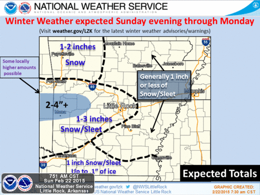
      Now there's still a certain amount of uncertainty with this next  round of winter weather that is plotted to move in. The uncertainty within the Models and the facts are, What Type of Winter Weather, and where. Timing is pretty much figured out, and amount. So you know me. We will go through this step by step. Okay so what you're looking st here is a map, issued by the National Weather Service. This is what their expecting and how much. Now North Arkansas getting any kind of snow is debatable because this is a Central/South Arkansas Storm. Now There will be a Narrow band of Snow in a Line from Fort Smith, to Little Rock. In that outlined area, I THINK we could see amounts up to 2" of Sleet and Snow, LOCALLY. There could be Isolated Higher amounts in Spots. Areas SOUTH Of Little Rock could see up to an INCH of Ice/Snow Mix.  Now For the Timing, Im thinking LATE This evening maybe around 7-9pm this will start to move in from the west. It Looks like a...

Early Week SnowMaker

Image
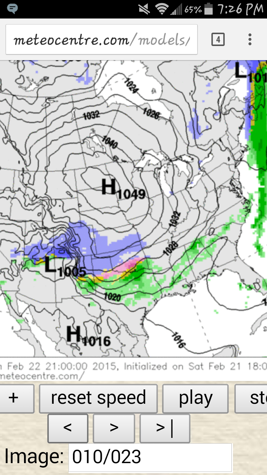
      Okay so This is the Third System that I mentioned in my Last Update. We are now Into the Night on Saturday evening. Now there is Still some uncertainty about this one,  but timing appears to be Late Sunday Evening through Sunday Night. MAYBE into Monday Morning. I have some Weather Models to show you then I'll explain what just Might happen. Okay now this is the NAM Weather Model. It Starts Everything Late in the Night On Sunday. But As we Know, this will Start Earlier in the Evening.  Now According to The NAM it Shows Frozen stuff over spreading the state By Midnight on Monday.  By 3am Monday Morning it shows Freezing rain over Central Arkansas. Now,  In reality that will go south, and that Blue area of Snow will be over Central Arkansas, with Maybe Some areas of Sleet in North Central Arkansas.  Now the NAM shows a Second wave of Moisture moving through with possible Snow LATE Monday Night into Tuesday after the First Wav...