Hey Everybody, How's it going? I HOPE that all of my Loyal Followers are SAFE, Right? I HOPE that Everybody that has read my Updates actually listened to what I said, and Stayed off those roads. I was driving around Midnight this Morning when the Freezing Rain started in the Little Rock area, at that time Temperatures were still a little elevated, the roads was just wet. But After about 3am, Everything went downhill when those Frozen Storms moved in! ThunderSleet is a Once or Twice In a Lifetime Phenomenon, it's not something you normally see, and whenever you do see it, it's usually never a good sign of what's happening at that moment. Frozen Storms tend to produce very high accumulations of Ice, and it causes very Crippling issues the longer they last. Thankfully for us, the Frozen Thunderstorms didn't last Long.
First I want to Take a Moment and Wish My Condolences to ALL of the Victims of the Major Car Accident in Fort Worth Texas this Morning. I know 3-5 People have been confirmed deceased, I do have Followers from Texas, I pray for you guys as you move past this very tragic incident.............. That is why I do this, that's why I word things the way I do and speak with the Ugency I do, some people make fun of it, but Life is VERY Fragile, and It's NOT something to joke about.
Now Moving on to what's NEXT???? So Friday afternoon we'll thaw out from this inconvenient Ice. We'll head into this Valentine's Day weekend rather unassuming, and rather quiet. Moving into Sunday, Valentine's Day 2021 is when I think the Winter Weather will return. Now the GFS, NAM, and EURO Weather Models are all consistent with Scattered Snow Showers at some point during the day on Sunday the 14th in West, and West Central Arkansas. Central Arkansas may not be excluded from that. Check it out.
This is the latest run of the NAM (North American Model), this particular model does show Scattered Freezing Rain/Sleet in West Central, Central, and East sections of the State, even South Central areas can possibly see some frozen precipitation On Sunday Afternoon. The other two models that I study are congruent with this as well.
Now this is the GFS Model (Global Forecasting System). This model shows the Onset of the Precipitation being in the Overnight Hours Sunday Night into Monday Morning in West Arkansas. This Storm moves in as Freezing Rain/Sleet, and quickly transitions over to a Medium to Heavy Snowfall.
This is the GFS in between 6am and 9am Monday Morning, this stuff moves into Central Arkansas as More Sleet than anything, then transitions to Snow as the morning moves in.
This is the GFS between 9am and Noon Monday, the main frontal boundary has moved into East Arkansas, and looks to be exiting by Early Afternoon Monday.
Now It's Worth Noting, that if this Frontal Boundary moves in with as much energy as it's projected to, that we may see some "ThunderSnow", which will probably produce high accumulations of Snow/Ice. No word yet on any Expected Accumulations. It's ALSO worth Noting that Cold air will Already be in Place on Sunday with Temperatures probably never getting out of the 20s, and with that type of air already in place, everything that fall will be frozen, whenever, and wherever it does fall, and everything that fall will STICK to whatever it falls on.
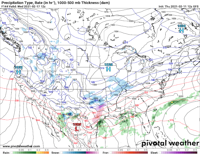
Now Let's move on to System Number 3! This System is hinted at by both GFS, and EURO Weather Models. This system has a Projected onset of Tuesday Night, Into Wednesday, and Lasting the Day Wednesday, and Lingering into Thursday Morning. I'll share a few Screenshots of the GFS Below.
This is the GFS between the Hours of Midnight and 6am Wednesday Morning. As you can see, there's some scattered snow showers around the state, but not much.
This is the GFS out to Noon on Wednesday with Precipitation Picking up, especially in Southern Sections of the state as the Moisture Rushes in from the South.
This is the GFS out to 3pm Wednesday Afternoon. The heaviest precipitation remains mostly centered to Southern, and Eastern Sections of the State.
Now this is the GFS out to Midnight Thursday Morning, It appears that the first Wave of Moisture is exiting East Arkansas heading into the Overnight Hours Thursday Morning.
This is the GFS out to 6am Thursday Morning, this particular Model shows a Second wave of Moisture which will also be in the form of Snow moving through Sections of the State.
Now, let's remember something here, this is 1 Full Week Away. "Long-range" Weather Forecasting is NEVER 100% Accurate this far out. This is Subject to Change, and get a little bit more detailed on Intensities, and who gets what, and how much, and When.? None of this will remain the same, the details will change over the coming days, but this Storm is Not going away. So it's going to happen. As the models get more buttoned down with this, I will do More Updates reporting the Changes! STAY TUNED, because we're not Done with Winter YET! Like, Share, and Subscribe to the Blog, stay safe Everybody!


Comments
Post a Comment