Winter Weather Update: ANTARCTIC Express???
Hey everybody, how's it going everybody? I hope Everybody is remaining warm, and safe today. Most of the Ice from Yesterday's Storm is gone, but however we have more winter Weather coming, TO SAY THE LEAST!!!! I have never seen Subzero Temperatures here in Arkansas in my 28 year old life.... Not that I can remember anyways. But It's looking like a true possibility here in Arkansas, and Central Arkansas. Let's just get right too this.
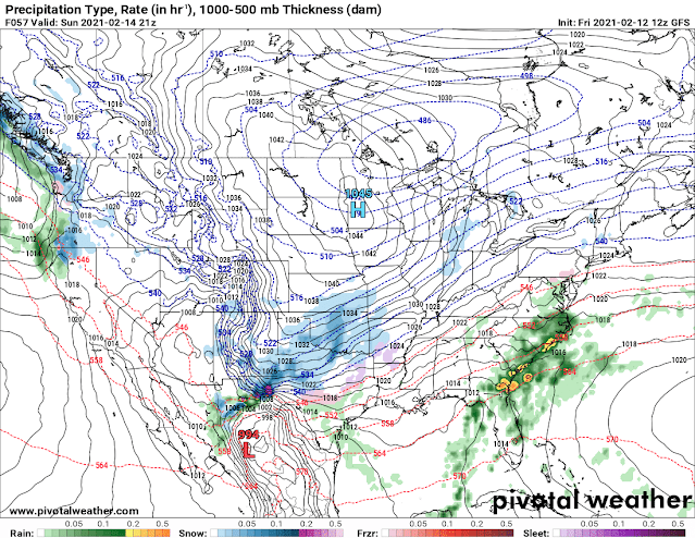
Now as far as Sunday goes, what's New? Well Both the NAM, and GFS Models wants to bring in an early Wave of Precipitation on Sunday Morning, and afternoon. The GFS has everything very scattered with Majority of the Precipitation in West Arkansas up until Sunday Night, into Monday Morning. The NAM wants to bring an entire Wave of Moisture through on Sunday Afternoon, then another wave overnight Sunday and Into Monday Lasting through Monday Afternoon before getting out of here.
This is the Latest Run of the GFS (Global Forecasting System), this particular model shows the onset of the Winter Precipitation between the Hours of Noon and 3pm Sunday Afternoon, in a very scattered fashion across West Arkansas.
The GFS keeps everything Scattered over Night up until about 6am Monday Morning, then it brings the main wave of Moisture through! This is projected to start as Freezing Rain/Sleet, then Changeover to All Snow.
This is the GFS out to Noon Monday, and as you can see there's a complete changeover to all Snow as everything exists the state Monday Afternoon.
This is the NAM (North American Model), this particular model brings a Wave of Moisture in Sunday Morning, everything is light it looks like, and scattered in nature.
This is the NAM out to Midnight Monday Morning, this particular model sets up a wave of Moisture in West Arkansas, then bring it through in the predawn hours of the Morning.
This is between Midnight and 6am Monday Morning. As you can see, the NAM isn't as persistent on Sleet as the GFS is. The NAM shows some, then Bam, a changeover directly to snow.
This is the NAM between 6am and Noon Monday Morning. The NAM is persistent on an extended period of time of heavy Snowfall for the Majority of Arkansas through the morning, and into the Afternoon Hours. The NAM has all of this Gone by 3pm Monday Afternoon.
Now As far as Who will get How Much? Well, that will depend on exactly where the Snow Bands set up, and how heavy they are in intensity.? This is just a matter of "Dart Play" basically. But as we get closer in time to Sunday, the Models will do a better job and Nailing down exactly where the bands setup, then we can guesstimate who gets what.
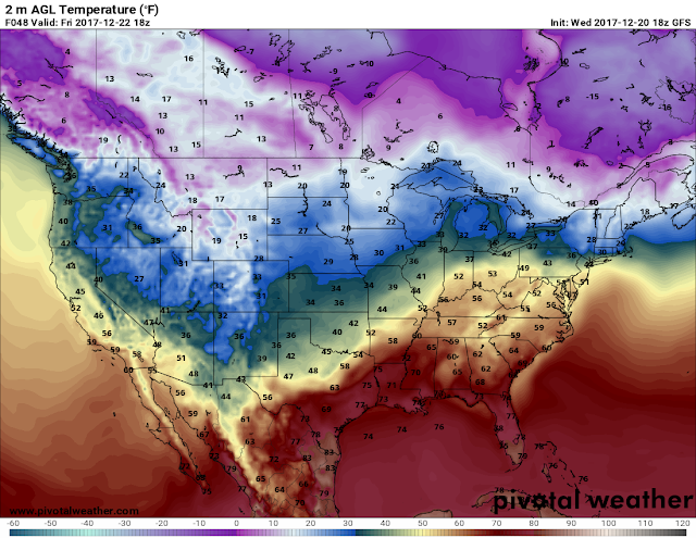
Now SNOW is just ONE part of this Train, the Other part of this Train is TEMPERATURES!!!!!! Dude we have some seriously cold temperatures on the Horizon. Sometimes Weather Models have a tendency to "Overdue" totals, and Temperatures. So we'll have to see if they don't warm up. But the Models both NAM and GFS had been trending colder and colder over the previous model runs. Take a Look below.
This is the NAM Surface Temperature Map, this map is projecting a Low temperature of 12° for Little Rock, and 7° for Fort Smith between the hours of 12Midnight, and 6am Monday Morning. There will be Snow, Sleet, and Freezing Rain in the State at this point in the morning. Obviously, anything that will will stick.
Now, It's worth Noting that I don't see a significant warm up in between now and Sunday/Monday. So when all of the Moisture moves in on Sunday Night/Monday Morning, EVERYTHING that fall will stick to the roadways and other surfaces. Because the Cold air will Already be here in Place when everything start, the Road conditions will get VERY DANGEROUS VERY QUICK. By Monday Morning, if these temperatures, and Precipitation maps verify, ROADS WILL BE INOPERABLE!!!
This is the GFS out to 6am Tuesday Morning ............. LOOK AT LITTLE ROCK......
*Drops Mic*
Thanks for Coming here to the Blog, Like, Share, Subscribe, if you have any questions, please, FEEL FREE!


Comments
Post a Comment