Valentine's Day Eve 2021 Winter Weather Update
Hey Everybody! Happy Valentine's Day Eve 2021! I have a Feeling I'll be doing another Update tomorrow about this storm. But since the Very Basics of the Storm was Covered in the Last Update, I will only go over the Changes between Yesterday and Today in this one, that way I'm not repeating myself. If you haven't seen the Last Update "Winter Weather Update: ANTARCTIC Express???," You should DEFINITELY check it out for sure! Like I said, not much has changed, the Models are disagreeing about the Onset of when everything Starts, they're also disagreeing with intensity, and exactly where the Snow Bands setup, which is typical, they usually don't agree until the day of, then they'll line up. They also don't agree with Temperatures. The NAM (North American Model) is warmer on Tuesday Morning than the GFS (Global Forecasting System), and the EURO (European Weather Model).
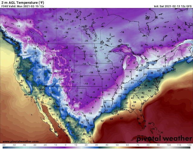
This is the GFS surface Temperature Map, this has us at 11° here in Central Arkansas between Midnight And 6am Monday Morning. Now Yesterday this Model had us at 14° at this exact same time Monday Morning. So this Model has gotten Colder on Monday Morning overnight. The NAM has us at 14° at the Exact Same time Monday Morning.
This is the GFS out to 6am Tuesday Morning, this has us in Single Digits in Central Arkansas. But if you Remember YESTERDAY, This Exact same Model showed NEGATIVE 4° here in Central Arkansas. So this has Warmed up to above Zero Overnight which is Good! The NAM has us at 19° for the same time Tuesday Morning.
It's safe to Say that Monday and Tuesday Morning, regardless of the Number the Temperatures actually are, it will be BONE CHILLING Cold here in Central Arkansas, with fresh Snow on the Ground.
Now Speaking of Snow, both the Models bring us Snow Overnight Sunday and Into Monday Morning. The Models disagree on Where? And Intensity. Which is very typical because nailing the location of where these Snow Bands Setup is a matter of Dart's play.
This is the GFS out to 6pm Sunday Evening, this shows scattered Precipitation across the central 1/2 of Arkansas. But anything accumulations from these scattered Light Snow/Sleet Bands will be VERY LIGHT!
This is the NAM at the Same Time, out to 6pm Sunday Evening. Shows very scattered/light snow/sleet showers across the state, with a snow band setting up in West/Northwest Arkansas.
This is the GFS out to Midnight Monday Morning, shows snow Bands moving across Central into East Arkansas. Like I said, where all of this set up is going to be random.
This is the NAM Weather Model out to Midnight Monday Morning, as you can see it packs in the intensity a Little Bit More, it's a little more Centered around Central Arkansas. I tend to Coincide with this model Moreso than the GFS.
The NAM has a Second wave of Moisture Moving through in the Form of Snow Between the Hours of 6am and 12Noon on Monday. The GFS has everything Gone by this time Monday.
So as You can see, there's some Discrepancies with the Models and the exact details. The models will line up more as we move into tomorrow, and things become more clear they'll start to polish up a little.
The National Weather Service is calling for 5-6" of Snowfall, this does include any Sleet or Freezing Rain that falls beforehand. This is through Monday. So by Monday Afternoon we should see totals nearing 1/2 Foot of Snow. Obviously with a Storm of this Magnitude Cities will shut down and Most people will be at home.
This will not be a Historic Snow Storm by Far, this is actually a Very typical Snow Storm for us here in Arkansas, it has just been a long time since we've had a Storm of this Magnitude, try 2,000 Days lol. Now if you need to do anything, I suggest you do it today because By Tomorrow evening, you're in the house for the next few days. Thanks for coming here to the Blog, and Stay Safe Everybody!


Comments
Post a Comment