Posts

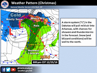
WINTER WEATHER UPDATE JAN 5TH 2017

Image
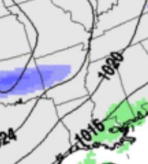
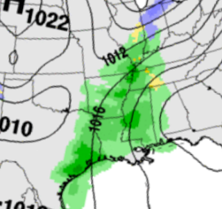
      Hey everybody, How's it going!? You know I try to make this as professional as possible, but BEING ME (Omarr Wilson) is DRAINING..... I wish y'all understood LOL!  But I digress!  FIRST WEATHER UPDATE OF 2017!!!! Starts with FUN! The WEATHER is the Developing Story right now so Let's get to it!     What's going to Happen!? ........ Okay so what we have is an Artic Trough Diving South through the Plain States, and at the same time, we have a System pulling moisture North from the Tropics. It's SIMPLE, mix Artic air with Moisture, and What do you have?  SNOW CITY.     What does the Models Say?.......  Lets start with the GFS (Global Forecasting System). This is a Screenshot of the GFS Early Tomorrow Morning, you see precips starting to move into the State.  This is the GFS Tomorrow evening (Cold air moves faster than Computers can understand so they slow it down, but in reality this image will be most likely Mid M...

New Years Eve/New Years Forecast 2016/2017

Image
     Hey Everybody! How's it goin! I'm coming with an official Forecast for New Years Eve 2016/ New Years 2017. Everybody has been counting Winter out just because we had a Mild and HUMID Christmas, Last Christmas was Even More Warm than this one and not long after New Years Winter REALLY KICKED OFF! Now back in February of this year we had two Blizzards, the First one was NASTY! I was Caught in it... The Second was bad, but not as bad as the first one. I think the second was in March. Now, with that said, IN NO WAY do I think this will happen this winter, I'm just saying this to say that a Warm Christmas means Nothing! Now on to the Forecast below!      Okay, Starting with Wednesday (Tomorrow), There is a disturbance moving past the state so Showers (Scattered) are possible from Little Rock on South and East. NO SEVERE WEATHER EXPECTED, Just the possibility of Scattered Rain. Now heading into New Years Eve, there is a Storm System that will be gathering o...

Christmas 2016 Weather Forecast

Image
     Hey everybody MERRY CHRISTMAS EVE!!!!  Im soo sorry I'm late with my update, I been busy Christmas Shopping, then food Shopping, and NOW COOKING! I'm doing this Update While waiting on my Pecan Pie to get done. So I have to make this Quick!      My official thoughts on Christmas Day, and Night. I don't think Christmas will be a COMPLETE Washout, I think in advance of the Front we have moving through showers will be spotted at best, and Isolated. But when the front move through Showers and storms will pick up. Y'all know the theme of this, Squall Line moving from Left to Right Across the State. I DO NOT, I REPEAT, I DO NOT expect much in the way of Widespread Severe Weather. I expect exactly what we've been getting. Moderate rainfall, Lightning and Thunder. I don't expect much bad weather with this. The parameters just aren't there.      Timing, as far as timing goes, I do expect the front to move through around Midnight or a tadd ...

Severe AND Winter Weather Update 12/13/2016

Image
Hey Everybody, How's it Going!!  We have A lot to cover so I'm warning you now, this will be a lengthy Update.! So lets get right into it. This Past Weekend after all of our nice rain, we didn't get much in the way of flurries or snow at all, which was to be expected. But Saturday the Models started hinting on Possible Snow Next Weekend. Some Forecasters got all in a tissy on Social Media then people started talking about "Snow" for NEXT weekend which was THEN 7-8Days away! Let me tell y'all something people, NEVER, and I do mean NEVER BELIEVE a Person be it a Forecaster or any Weather Source when they say "There's a chance for Snow", But that Chance is 8 DAYS AWAY! Long Range Forecasting (Beyond 3-5 Days) is NEVER set in stone. Weather Models go as far out as 12 Days but Only the first 4 days of them are Credible You Understand me? So If it's beyond that 4 day period it's ONLY SPECULATION!!!!!!!! REMEMBER THAT!     Now that I got that o...

Fairly Active, And Cold Weather Pattern To Come

    Hey everybody, How's it going!  I just want to say I hit a huge spike in viewers here on the Weather Hawk's Blog on my Weather Update from Yesterday. I SERIOUSLY Appreciate everybody for coming here to the Weather Hawk's blog for Weather Information. Now Let's get into our active Weather Pattern Shall we!?     First thing's first, I've been Looking at the GFS (Global Forecasting System)  weather model, and it's very cold on Wednesday Night, and into Thursday of This week. Possibly Freezing-Subfreezing Temperatures in West, and even into parts of Central Arkansas. The NAM (North American Model)  is ALSO showing the EXACT same thing! Now the Timing on the air according to the Models is Late Evening on Wednesday.... Here's my deal with that, WEATHER MODELS ARE NOT GOOD WITH COLD AIR! Cold Air is Heavier and more dense, so it falls towards the equator quicker than our Computer Models can calculate! I'd bet my Bottom Dollar that IF THIS VERIFY, it wo...

Late November Severe Weather Update?!

Image
    Hey everybody, how's it going!? Y'all remember on Thanksgiving when I made a Weather Update to social media, I mentioned a chance for showers and thunderstorms this coming week. Well that chance has held true, In fact, there is Too much of a chance for rain then we NEED! More on that in a sec, but not to mention, this storm system is associated with a front, so needless to say that brings along a certain risk for severe weather! Strong Winds, Flooding, and ISOLATED Hail will be the main concerns BUT, the chance for Tornadoes IS PRESENT!  Not a Particularly Big/Great chance for Tornadoes, but it's NOT IMPOSSIBLE, even for this time of the year, IT IS ARKANSAS, ANYTHING is Possible!!! So, without further babbling on CHECK FORECAST BELOW! This Map is courtesy of   the National Weather Service here in Little Rock. The first Story here is WIND! Wind Gust up to 35mph in areas around the State as of Sunday Night. This is in part due to the strength of this st...

More Active Weather?? Dehydrated Fall? What's going on?

      Hey everybody, how's it going !!! Man this has been One DRY Season aye!! We haven't had very much rain since Early September! High pressure set's up and it's resilient, it hates budging! But now that the climate is now starting to switch into a cooler more Fall/Winter feel/vibe the rules to the game are changing. We have a Low pressure system that's making it's presence known in more ways than one! First, this system is bringing the FIRST BLIZZARD of 2016 to the Central United States Plains. Montana, Kansas, Nebraska, and South Dakota are in the cross hairs! Now we will be on the Other side of the stick when it makes it out this way!  We won't get no snow, but what we will get is a broken Line of Showers and Thunderstorms Late in the morning on Friday (Tomorrow), SOME OF THOSE STORMS COULD BE STRONG!      I Do Not Foresee a threat for Tornadoes or anything like that at this point. I do however, expect there to be some type of Strong Wind Threat ...