Posts

SEVERE WEATHER UPDATE:❗ Mid-Week Trouble !❗❗

Image
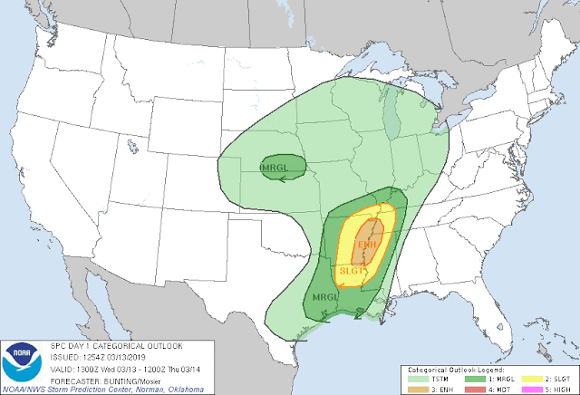
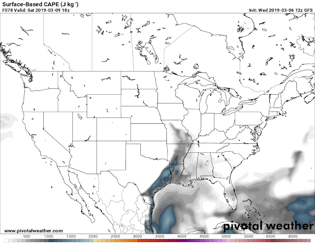
         Good Morning everybody, how's it going?! I hope everybody is having a safe, and Fantastic day so far. It is that time of year. Severe Weather Setup, after Severe Weather Setup, they are rolling in like Clockwork now. So following Saturday's Storms, which came as expected; with Isolated tornadoes, and strong to severe wind. No fatalities, no injuries, everybody heeded the warnings very well. There was some misconceptions about the matter of Tornado Sirens, and how they work, I'll make a separate post about that. But as far as today (Wednesday March 13th is Concerned).        There is a system making it's way from the West, it should be here inbetween now, and this afternoon With it comes the Wind Energy that's needed for Severe Weather, combine that with moisture coming up from the South, and we have a mixture of Instability on our hands which means Severe Weather.  So as far as I see right now the primary focus will be on the s...

Severe Weather Update 3/6/2019: Saturday Storms

Image
      Good Afternoon Everybody, I hope everybody's having a fantastic day so far. I've been watching over the models, and I've noticed that there is a system coming in this weekend. This will pose some sort of Severe Weather this weekend.     The wind field with this particular system will be substantially strong. Anytime you have a strong wind field, with moisture, and some Instability (even a little bit), there lies a threat for Severe Weather. So, with that being said, there is a threat for Severe Weather on Saturday afternoon for South, and Central Arkansas, and Saturday Evening for East, and Southeast Arkansas. The threat for Tornadoes is low at this time, the main concern here is Damaging Straight Lined Wind. Tornadoes will not be ruled out. It's only Wednesday *This May Change in the coming days*.  This is the 6am Wednesday Morning run of the GFS (Global Forecasting System), here it shows CAPE values highest in South Central Arkansas. CAPE sta...

Feburary 22nd 2K19 Severe Weather Update: Weekend Worries

Image
       Hey everybody, how's it going!? I hope everybody is having a safe, and fantastic morning so far. I was supposed to do this Update last night, but I got busy at work. I'm sortof glad I waited because my feelings have changed about this developing weather situation abit. Check out why.        Okay, so Yesterday I was pouring over the model guidance of the CMC, NAM, and GFS, and I was seeing a bit more of a punch of Instability on Saturday Morning, and Afternoon, seeing that heightened my concern for Severe Weather including Tornadoes for parts of the state. But this morning, looking at the latest run of the models, it looks like the majority of the threat for Severe Weather has shifted to the East of the State. So areas like South Tennessee, and West/Northwest Mississippi has the better chance for Severe Weather, and a possible Tornado Outbreak. So my level of concern have shifted mostly out of Arkansas, on off to the East.     ...

February 6th 2019 Severe Weather Update

Image
        Hey everybody, how's it going!? I hope everybody is having a fantastic day so far. Right now Im watching a Developing threat for Severe Weather here in the State. At this current hour 13:15 Wednesday February 6th, 2019 there are Storms in the state up north, and west. Right now they are Below Severe Limits. But based on the Instability measures in the state, they do have the potential to become Severe at any time.         Now, with the aforementioned being said, I do not think we will have a repeat of "Super Tuesday" February 5th 2008, but there is a chance for an isolated tornado if one of those storms get organized. Organization isn't present at this time, but if there is any, a tornado may be possible. The only threats here is High, damaging Thunderstorm Winds. That's the only primary threat I'm concerned about at this point. If any watches, or warnings are issued, they will be immediately broadcasted on my social media. I will post an...

Winter 2K18/19 Will NOT Be Denied!!!

Image
       Hey GoodMorning/Afternoon everybody, how's it going!? I hope everybody is having a fantastic day so far, and I hope everybody has had a safe and enjoyable New Years!!!! It is my first update of 2019, and I'm making it about what I love! WINTER! Winter in Arkansas has made a return! Just when everybody said "Winter is dead", "Winter is over".... Winter will not be denied here in Arkansas! WINTER IS NOT OVER UNTIL IT'S OVER. So let's dive into what's to come shall we!       Okay so I know everybody know by now that there is a System moving into the mid south, coupled with cold arctic temperatures coming in from the north associated with a front. It's been all over the news, now as far as the dynamics on this system, and how it impacts us here in Arkansas.?At this time, the latest run of the NAM (North American Model) is showing plain Jane rain for everywhere south of North Arkansas. Could we see a Mix LATE Friday evening, into Friday ni...

Official 2018 Christmas Forecast

Image
       Hey everybody how's it going!? I hope everybody is having a fantastic night so far, I hope everybody has had the opportunity to get all of their Christmas shopping in, the stores have been crazy, and the good thing is, the weather has been cooperating for the last few days, and that's has been very appreciative to say the least. Now the question is, will it stay like this? I have your answers below.!       Okay, so as far as rain, the GFS has it dry through Christmas, which is a change from days, to weeks ago. I don't totally buy it at the moment, I don't think the entire state will be dry, Little Rock? maybe! Or, maybe a scattered shower early in the day, but for areas in North, and West Arkansas, there is a chance for showers early in the day on Christmas, the latest NAM shows it. Now, weeks ago the GFS was showing snow for Christmas, I did an update about that showing that it was in the realm of possibilities, but you see how probable that i...

PRELIMINARY Christmas Winter Weather Forecast

Image
      Hey everybody, how's it going? I hope everybody is having a fantastic day so far! I've been watching the GFS very closely over the last 6-7 model runs, and I've been watching something fairly interesting over the last few runs. The GFS has been fairly consistent with the possibilities, but inconsistent with the exact time, and locations as to be expected from 300+ hours out into the future. But from this far in advance the GFS is fairly consistent with the possibilities. So let's take a quick look shall we!? This is the Tuesday noon run of the GFS (Global Forecasting System) weather model, and as you can see here, the GFS has a system moving in from the Southwest, and a arctic front moving in from the Northwest , combine those two, and this is the obvious possibility. But this image has changed in location, and time over the last 4-5 runs, so it will change much more over the next. But this particular model has been consistent with this particular outcome, or ...