Posts

**SEVERE WEATHER UPDATE** Frightening Friday Weather Coming

Image
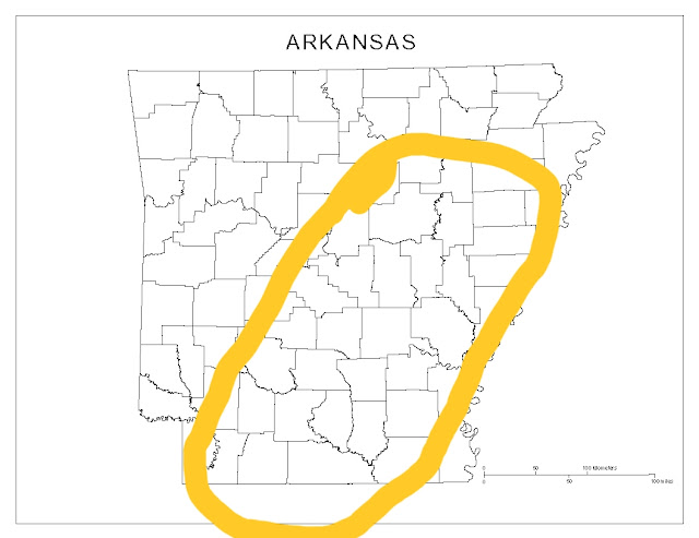
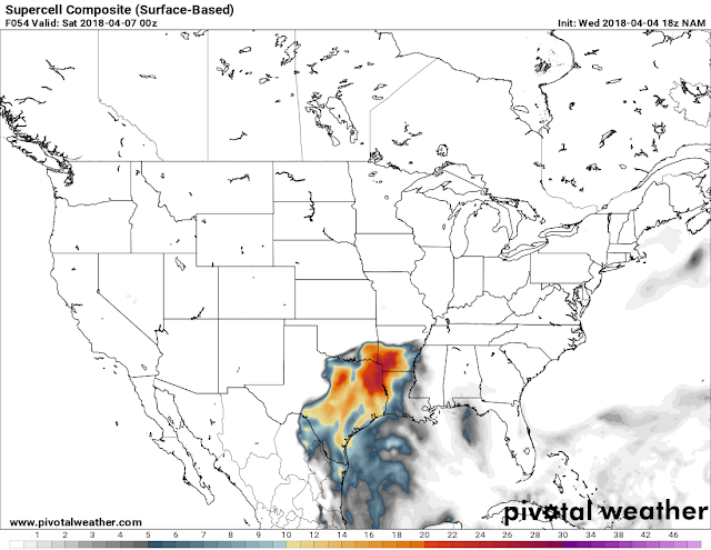
      Hey Everybody, how's it going on this Thursday night. Unfortunately a harsh reality of spring in Arkansas is Severe and potentially Deadly weather. Tomorrow is one of those days where we will definitely have some of that weather. Now this will be a very typical spring severe weather set up for Arkansas. We will have a front moving in with a certain amount of instability which will be sufficient enough for Supercell thunderstorms to develop, and rotate, and produce tornadoes. Now down to the meat and potatoes.........       What everyone wants to know is what are the risk for tomorrow.? Well at this point EVERYTHING is a risk, Wind, Hail, Tornadoes the whole 9! I think the area with the Highest chance of Severe Weather is this outlined area below: If you live ANYWHERE in that outlined area; I expect Severe Supercell Thunderstorms, I expect storms with Strong Winds, Large hail, and large violent Tornadoes ARE POSSIBLE in that outlined area! Thi...

More Severe Weather Ahead

Image
      Hey Good Evening everybody, how's it going!? I've been looking over the model data from the NAM and the GFS weather models, and it looks like there's yet another chance for Severe Weather on the horizon! I don't think this will be as widespread as the most recent Severe Weather event we had yesterday. But it will be something to watch for Southwest Arkansas.       This system will be in the form of a Squall Line with moisture streaming in from the south on Friday. Now with this it seems that earlier into the evening the chance for Tornadoes and Supercell thunderstorms is confined to Southwest Arkansas. However the threat for strong winds, and large hail is statewide as that Squall Line moves through later in the night on Friday. See Pictures Below: This is the noon run of the NAM. This map is valid around 6pm Friday evening, as it shows the area with the highest probability of severe storms is in the West/Southwest corner of the state. This i...

**SEVERE WEATHER UPDATE** Monday Madness

Image
     Hey Good Afternoon everybody,  how's it going!? Unfortunately the time has come for a threat of more Severe Weather here in Arkansas. The particular area of the state that I'm expecting to see the worst of the weather has already seen their fair share of severe weather this year already, and the season just got kicked off! East, and Northeast Arkansas. Areas to the East along, and to the North, and South of Interstate 40, generally East of the Little Rock metro is where I expect majority of the bad weather to be confined to.... This is based off of just timing of the Front itself! See Pictures Below: Okay this is the Latest Run of the NAM (North American Model) this map is Surface Based Instability, this is around 6pm tonight and as you can see the instability is confined to areas north and south of Interstate 40 in East Arkansas. This is where we find our greatest chances for Severe Storms. This is the NAM Tornado Map this is where the model guesstimate...

Official Easter Arkansas Weather Forecast 2K18

      Hey everybody, How's It going?! I hope all is well. I've been getting tons of questions about what the Easter Weather is looking like for Arkansas this year, so I felt driven to do this update. Now I constantly follow the weather, and stay updated on what's going on. I monitor the models DAILY whether I post an update or not, I'm always looking at what's going on in the models, and with the weather. Over the past week or so, I've been seeing rain possibilities over different areas of the state for Easter Sunday.... Now at this current time, I've narrowed everything down to one certain section of the state, and what exactly they will be seeing.!       Okay, as far as who will get what... At first I was thinking areas of central, and south Arkansas. But now the way it seems, the models have been trending south, and north. The NAM (North American Model) is showing scattered showers in far South Arkansas, and scattered stuff in far North Arkansas. NOW, a...

More Severe Weather? Or Nah? My Thoughts?

Image
     Hey Good Evening everybody! How's it going?  I hope everybody is safe and well after Saturday's storms! I know there was 1 death in far North Arkansas in Clay county along the Missouri border. That death was during 1 of 2 Tornadoes reported on Saturday during that Severe weather event. Arkansas is in the top 5 of the states in the south with the most Tornado related fatalities! Now this statistic doesn't come as much of a surprise to me because I know that people here in Arkansas don't take weather seriously. Severe Weather and Tornadoes are a big joke to a lot of stubborn people here in Arkansas, and that's mainly due to the lack of education on how dangerous these storms can be, and/or the lack of preparation. When Severe Thunderstorm Warnings or Tornado Warnings go out for your area, IT IS REAL...This stuff is not a game, it's not a joke, I don't do these updates to stay in shape, I do it because it's SERIOUS, and these updates contain informat...

**SEVERE WEATHER UPDATE** Severe Weather Saturday

Image
     Hey GoodMorning Everybody! I hope everybody had a safe day yesterday, there was well over two dozen accident reports across Central Arkansas. I hope everybody that follows my weather, and visits the blog took my advice and drove safely. Yesterday did exactly what I said it would do by just adding on to our rain totals making them way worse in areas that do NOT need anymore rain. Today (Saturday, February 24th) will be no different, only exception with today is the fact that we will have Severe Weather, and Tornadoes to deal with!      Now how bad is it going to get? And where?..... Well just like I stated yesterday, we will have a front that will move through today and put an end to the deluge of rain we've been getting. But with that front will come the chance for Severe Weather due to the increase in warm moist air that will meet with this front over Arkansas. The warm air will be most abundant and unstable on the EAST side of the I30 Corridor, so f...

FIRST ***SEVERE WEATHER UPDATE*** OF 2018 !!!

Image
     Hey everybody, how's it Going! This has been a very rainy week here for the entire state! We've REALLY needed the rain coming out of a fairly dry Fall, and mostly dry Winter to be honest. BUT, what we didn't need was all that rain at ONCE. So now, we have a serious Flash Flooding issue, this is SO serious to the point to where a School District here in Central Arkansas has cancelled classes for the remainder of the week just due to county roads along the bus routes being completely flooded out! This comes after a school bus and it's occupants had to be rescued because the school bus lost the road while traveling through flood waters. So since then the entire district has cancelled classes. You know the problem is LEGIT when the School District takes a Weather Day when it's not even Winter Weather Related! This nuisance rain comes from a front that moved in earlier in the week, stalled out to the south, and has allowed disturbance after disturbance to ride up al...