Posts

November 30th 2018** SEVERE WEATHER UPDATE **

Image
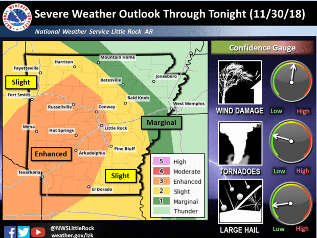
      Hey everybody, how's it going!? I hope everybody is having a fantastic day so far, I just wanted to bring everybody up to date on this developing Severe Weather Situation here in Arkansas this evening. I've been meaning to post this update, but I'm just now finding the time to, so let's get to it, because this is serious business.       Now, as far as what is expected today? Well as it sits, ALL MODES Of Severe Weather is Possible this evening, and tonight! There is Definitely a Chance for Damaging Thunderstorms, Hail, and there is a threat for Tornadoes. Obviously the main concerns are wind, and hail, and lightning. BUT, Tornadoes are a Legit possibility tonight! Night time storms are particularly deadly because you cannot physically see the weather coming. So HAVE YOUR NOAA WEATHER RADIOS ON! And, Keep the News on Standby, as well as Pay attention to all Social Media News sources for weather information. This is an Outlook Map Courtesy of the...

2018 Turkey Day Forecast!!

Image
       Hey everybody, how's it going! I've been pouring over the model guidance over the past few days surrounding, our weather for Thanksgiving day, and Black Friday. The models have been fairly consistent with temperatures, as well as any rain chances. So Let's get right to it.       Now as far as temperatures on Thanksgiving Day, the temperatures look to be in the Low to Mid 40s around the state on Wednesday night heading into thanksgiving morning. So for everybody that will be camping out for the Thanksgiving Black Friday Sales, it will be chilly the morning of thanksgiving. On thanksgiving day the temperatures should warm up into the Low to Mid 50s in most areas of the state. 50s isn't unbearably cold, but it's chilly, so dress accordingly. The night of thanksgiving the temperatures will dip back down into the Mid 40s heading into Friday. Then by Friday evening I'm seeing mid 50s again. On Saturday the GFS (Global Forecasting ...

WINTER WEATHER UPDATE: NOVFREEZE 2018!

Image
      Hey everybody, I hope you guys are having a fantastic night so far. Yes, you read the title right! It is the Official "Novfreeze" of 2018. Calm before the freeze! We have a chance at our first freeze of the year, and when I say "FREEZE" that's what I mean. I'm about to go over how cold? What time? And Will there be anything extra? Check me out!       Okay, so as far as the first question, how cold...... The models have been consistent over the past few days for subfreezing air, I was supposed to do this update yesterday, but I started seeing changes, so I decided to wait a little while longer. Good thing that I did, because just 6 runs ago, the GFS (Global Forecasting System) Weather Model was very aggressive with an opportunity for some frozen precips, but we'll get into that in a second. But as far as how cold? Well the models have been very consistent with high 20s in Central Arkansas on Saturday Morning. Mid-Low 20s up North. Check it out. ...

SEVERE WEATHER UPDATE: For Monday November 5th

Image
       Hey everybody, I hope you guys are having a fantastic evening so far. In my last Update I discussed the severe weather chances for tomorrow, November 5th. Now, a few Model runs later I have some updated impressions I need you guys to be aware of.         Okay, as far as Timing, I stated that it wasn't really clear yesterday what time this stuff is expected to kick off. Now that I have a more clear picture, I'm expecting development to start in North Central Arkansas from the wave of moisture passing to the north sometime late tomorrow morning, into the Afternoon hours. By Afternoon tomorrow I'm expecting showers, and possibly some storms to develop around Central, and South Central Arkansas. I don't expect much of that to be Severe. Now as we get deeper into the Afternoon, and Evening hours tomorrow, from 12-6pm, I expect a Squall Line to develop as it moves into East Arkansas. I expect everything to be gone by 8 or 9pm (Severe Weather any...

Severe Weather Update : MONDAY MADNESS

Image
       Hey everybody, how's it going!? I hope everybody's having a fantastic evening so far. If you can't tell by the title, there is a chance for Severe Weather on Monday November 5th. Timing is still up in the air, some models suggest Noon - 12am for West - East Arkansas. Some models suggest Monday Night for just East Arkansas. I will be watching these models like a Hawk over the next couple of runs. Now, lets get into what to expect.       As far as what to expect, for awhile now the Tornado threat has not been impressive to me at all, the measure of instability is relatively low, but the amount of twist in the atmosphere, it's what we like to call "Wind Shear", there will be lots of it in the atmosphere on Monday, and Monday Night. So the chance for spin ups with the squall line itself is very prominent! Now, granted spin up Tornadoes are not the biggest in size, but they are fast, and they are capable of taking lives, and damaging property! So wi...

Arkansas 2K18 Halloween Weather Forcast

Image
       Hey everybody, I hope you're having a fantastic Sunday Evening! I've been pouring over the model guidance over the past several days, and I've been studying the chances for rain on Halloween day, and night.! I don't think the trick or treaters will like this one! I'm about to talk about rain chances, and temperatures on Halloween day/night, as well as the weather heading into our annual Susan G. Coleman Race For The Cure here in Central Arkansas on Saturday November 3rd.        As far as Halloween goes, there are definite rain chances in the forecast for Wednesday October 31rst 2K18. There will be a front that will move in late Tuesday night and into Wednesday. This front will be strong, so with it will come the chance for ISOLATED Strong to possibly Severe Storms. Now, I'm not expecting a widespread outbreak of Severe Weather, but there is a chance for some storms to be strong to severe. Now, the latest run of the NAM ...

Official Fall 2018 Arkansas Weather Forecast

Image
        Hey everybody, how's it going!? I hope everybody is having a fantastic evening. The time is finally here for me to give my official educated pitch at what this weather pattern will be like as we move through the fall months. I can make this Forecast today, and the complete opposite can happen  It should be noted that with Long range Forecasting (any forecast extending further than 7 days), everything is always in the air as it relates to accuracy. But when it comes down to it, I base my forecast off of education, instinct, and weather analysis. So, that being said, let's get to this Fall!       Now TEMPERATURE WISE; Today October 10th, 2018 is probably the warmest day we will have for at least the next 7 days. Now the front that brought brief spinups, high winds, and power outages to the state also delivered us the cooler temperatures that everybody has been BEGGING for! Today we got to the 80s here in West Little Rock. But at this time i...