Posts

Showing posts from 2014

Christmas Forecast

   Hey Everybody. Arkansas Weather Hawk here. First off, I hope everybody is having a great Holiday week so far. I know its busy, Cooking, Cleaning,Traveling, Buying and Wrapping Presents. But Hopefully everything is going swell. As far as your Weather goes. Well if you are traveling leaving Little Rock going towards the East Coast or the North East, You may have been getting delays and layovers. Simply because of a storm thats affecting the North East half of the Country. Now as far as Arkansas. We have RAIN For the most part in Parts of North Central Arkansas moving into Central Arkansas. It isn't heavy. Not frozen at this time. Just NORMAL RAIN. Now if you are traveling in North Arkansas OVERNIGHT Tonight and Christmas Eve Morning, Just be aware that the Rain MIGHT mix with some heavy wet snowflakes. NOTHING will Stick. Nothing will Accumulate or Cause any issues. Too Warm at the Ground for that. But just be aware. Don't let it scare you though. Here in central Arkansas I e...

Christmas Snow???

Christmas Snow??? Here In Arkansas Snow On Christmas is a Once in a Lifetime thing So to speak. Last time in recent history we had a good Christmas snowstorm was Christmas of 2012 . That was a Storm to remember here in Little Rock because I was out DRIVING IN IT!!! BLIZZARD Conditions, I remember Leaving Camp Robinson Rd. In North Little Rock, Got on I40, then Merged onto I30 South into Downtown Little Rock, and I was forced to Exit on E Broadway in North Little Because I30 at the river bridge was barricaded in both directions. So I had to drive through both Downtown North Little Rock, and Downtown Little Rock to get to my house in West Little Rock. The Scariest, Most Challenging, Most Interesting Driving I have done in my life to this Very Day. I'll never forget that or that storm. But the sad truth is, That storm Spoiled Arkansans. That storm now have us expecting snow or thinking about it. What Arkansas Locals must understand is that here in Arkansas, Storms to that magnitude ar...

Froggy Friday Weather

  Hey Everybody, How's it going! The Arkansas Weather Hawk here! I apologize for my absence. I moved, and it's been soo hard getting my network and servers setup at the new house. But everything is hooked up and running finally. Xfinity gave the Juice this morning after 2 weeks of shear working. Big Shout out to them. Now that that's out of the way, we have a chance for rain and storms tomorrow. Now there is somewhat of a severe threat. NOT in no way, shape, or form am I expecting any type of Outbreak or anything like that. But tomorrow morning on your way to work, class, or school, do expect rain, thunder, winds, and lightning. Honestly I'm just expecting basic thunderstorms. But DO NOT be surprised if you end up seeing a few Severe Thunderstorm Warnings. I'm expecting it to come from the south tomorrow morning 6-10am. Then as the front leaves the state there will be one more chance for scattered showers and storms SOME COULD BE SEVERE, tomorrow night (EARLY). Time...

Weather Model Wars!! WINTER WEATHER UPDATE!!

Image
     The GFS (Global Forecasting System) overnight run of the model data has intensified it's snowfall for areas of North Central and Central Arkansas. The GFS has tended to be fairly reliable in recent years. It is one of the Main Forecast Models weather forecasters look at for weather analysis. And It has really turned up the intensity it's snowfall amounts for Central Arkansas. Sometimes during the winter the GFS tends to be a little out there or dramatic.  But at times so does the NAM (North American Model).  Winter time is one of the most challenging and fun times to forecast and predict Weather in Arkansas because you just don't know what will happen. But the Overnight run of the GFS brings a heavy band of Snow/Sleet into Central Arkansas by 3AM Monday Morning. While I do think Central Arkansas will get some Type of Frozen Precipitation Sunday Night/Monday Morning the Jury is still out on how much,  or how heavy.  Now around the Same time of nigh...

WINTER WEEKEND FORECAST

Image
     Look forward to Cold temps today tonight, maybe a scattered shower or two this evening or late tonight. Tomorrow evening we have a chance for scattered LIGHT Snow Showers. Tomorrow night into Monday their could be a Dusting to an inch of Snow in certain areas around Central Arkansas. NO BIGGIE.North Arkansas Could see a Dusting to TWO inches In FAR North Arkansas. But North Central, and Central Arkansas will just see a Dusting to An inch. VERY LIGHT Accumulations. NOTHING MAJOR. So Yess Sunday Night into Early Monday morning YOU MIGHT see Snow once again around the Little Rock Area. #ARWX          A Winter Weather Advisory has been Issued for North Arkansas due to the Chances for Inclement Weather. This Advisory Area will be expanded South and East further into the state as time progresses.                             I am the Arkansas Weather Hawk and I gre...

ARKANSAS COLD AND FUTURE SNOW CHANCES

        Hey Everybody! How's it going!! It is the Arkansas Weather Hawk, here.  I know it's been a nice little while since I've updated the blog.  But sometimes life takes us down the busy road, and sometimes we just don't have time. That has been the case. But as you know we had a really active Secondary Severe Weather Season this fall, as I figured we would.  Well it's almost Thanksgiving, so that being known, it's time to shift our attention from mild Weather and Tornadoes, to cold weather and Winter.  Because here in Arkansas winter has NO PROBLEM, making it's presence known.  I think we've gotten that message Loud and clear over the past few weeks.  Last week we shattered a 20 year record with it being the earliest freeze here in Arkansas since the Year I was born (1993). Winter has moved in and made a rude loud presence.  Since that record breaking day we've had reasonably chilly temperatures here around the state.  With ...

Early Morning Storming

Weather models sped everything up I'm thinking 9-10am clearing Central Arkansas. STRONG DAMAGING Line of Storms expected hit Central Arkansas. The Wind will be strong. Damage Veryy Possible. Heavy rain, Flooding Possible. Tornado threat is Low. Spinups can and are very known to happen in Squall Lines within the kinks that develop within them. Although tornadoes are not Likely, I will not say it's impossible. It will be morning commute, people on the way to Work, kids on the way to school. Have your phones on you and BE VERY AWARE of what the Weather is doing around you, and what watches or warnings are posted for your area. IF any take IMMEDIATE ACTION. WhatEver it maybe DO IT! I do expect a Tornado Watch and a Severe Thunderstorm Watch to go out at some point for the areas ahead and along the front itself. This is the Arkansas Weather Hawk #ARWX 

Monday Storms

Image
      As If that squall line that moved through overnight Sunday wasn't strong or loud Enough, wait!!! There's More!!! There's a Slight Risk for Severe Weather Set up across the entire State of Arkansas today. The MAIN threats on this is the possibility for Strong Damaging Thunderstorm winds, and Large Hail. Other things of concern will be Vivid STRONG Cloud To Ground Lightning due to High humidity. Another concern will be Heavy Rain and Flooding. More often than Not streets flood up very quickly under intense rainfall. And heavy rainfall creates a dangerous driving Hazard. So Be CAREFUL. There's a front on or near the Missouri Border of Northern Arkansas, and it's Stationary. This will allow disturbances to flow into and through Arkansas along it. There's two chances or rounds of storms expected today. Round #1 Throughout the afternoon and evening hours. Round #2 possibly Over Night.  #ARWX Here's a picture of that State Wide Slight Risk area for Arkan...

More Fall Storms

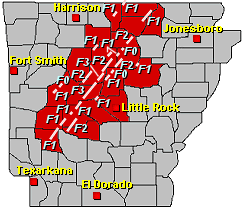
     Well as Stated over the past week and a few days, the Secondary Severe Weather Season here in Arkansas is something to take seriously, because it can be no joke at times. It appears that Thursday night here in Central Arkansas we did in fact have one Tornado Touchdown just moments after it moved through a very highly populated area of Little Rock. If that storm would've touched down before it got into Little Rock, it would have been a REALLY BAD DAY! Its a blessing that nobody was hurt in that storm. The Popup rotation was sudden so the Warning was good given the circumstances. Sirens did go off. All 58 of Little Rock's Warning Sirens sounded, and people took cover. VERY GOOD. But there was one fatality in Hot Springs Due to Damaging winds and a tree. It was really sad.       But Enough of that, moving forward to tonight and tomorrow. Late tonight there is a fairly good chance of scattered showers and storms. The Severe Threat for this one is fairly ...

THURSDAY TROUBLE

    Hey everybody, How's it going this morning. Hope You are all having a good morning so far. Well as I said on social media, I'm doing this Severe Weather Update Thursday Morning October 2nd, 2014 at about 8:10am. Now In this Update I did the Hazardous Weather Outlook From NWS Little Rock, and I viewed this morning's model runs of the NAM weather model over on Weatherbell. This is in no way shape or form expected to be an outbreak of no kind. BUT, Severe weather of all kinds are expected this evening and night. That's why I'm doing this because I want everybody to be AWARE, and keep an eye to the Sky. Life Threatening weather is possible today, so I want everybody to take it seriously. As I said I'm expecting a Messoscale Discussion to come out from SPC, and a Severe Thunderstorm, or possibly even a Tornado Watch at some point today. #ARWX As Always I appreciate all of you for coming to The Arkansas Weather Hawk for Weather Information, and Until I see...

Fall Severe Weather Season AWARENESS

Image
           It was nearly 5 years ago back in 2009, the state of Arkansas had its most active fall severe weather season to date. With 15 Tornado Reports and about 22 Severe Weather Reports, needless to say it was a pretty active fall. Fall Severe Weather season here in Arkansas typically runs from Sometimes Late September all the way through early December. Fall Months can be just as violent as spring months, and has been in the past. All due to similar climate conditions in both the season of spring and fall. Now 2009 was the most active in recent history for Arkansas. But 2012 wasn't very far behind with 13 Tornado reports mostly in October and November. I'm not saying this year (2014) will be like either of those years. I just want it to be known that Tornadoes can and do happen in the fall months before winter. So just like you do in the spring, take the warnings and notices VERY serious because here in Arkansas just like anywhere else, it could mean th...

More Severe Weather?

  Heyy everybody how's it Goin!? Arkansas Weather Hawk here. Just letting you guys know that these little "sprouts " in severe weather that we've been having lately, they are to be expected. You see, here in Arkansas we have not One, but Two different Severe Weather Seasons in which those times are very conducive for Severe Weather, and Tornadoes. Here in Arkansas some of Our most dangerous of Tornadoes has happened in the fall. Our "Secondary Severe Weather Season " generally runs through the fall months of Late September through Mid November. As the climate transitions from Fall to Winter, that environmental setting is nearly Identical to our Spring Setting simply because Spring and Fall are What I like to call "Transition Seasons", so their very similar in terms of how the climate is set up. So just like Spring is prime time Severe Weather and tornado time. Fall can be just the same. So as we move into our Secondary Severe Weather season beware ...

2014 Fall&Winter (Initial Thoughts)

     Heyyy Everybody, How's it Going? Today's Update is just meant to share my first thoughts regarding this year's fall and winter. Now later on I'll upload a indepth analysis of how I expect the winter and fall to play out. But upon first Thoughts. I'm thinking this will be a more cooler and possibly wetter fall than average. Due to our incredibly unusual summer we've had. Our summer has been both cooler and wetter than average, and we ended up breaking a few records this year because of that. Now the way the summer goes generally tend to set the vibe, or dictate a lot abt how the winter will go. If it's a summer where we've gotten days of 100°+ temperatures. Then we'll ether get a late winter or alot of Ice. If it's a cooler summer then it's a cold potentially Winter Storm Type winter. And that's the Vibe that's coming off of this years summer. Simply because the ground has practically No leftover heat from the summer. So when it g...

What Actually Causes And Actual Lightning Flash??

Image
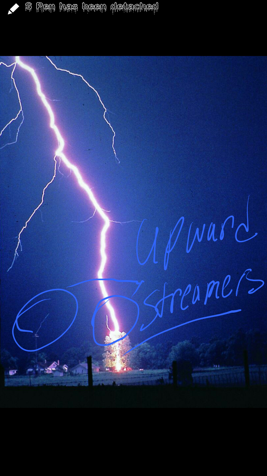
        Okay Guys,  so remember Yesterday I talked about the Birth of Lightning. Stepped Leaders, and Upward Streamers. I talked about what has to happen before a Bolt of Lightning to happen. Now as for a Lightning Strike itself. How does That Process Work? Well The entire Stepped Leader Process happen. Now once the Stepped Leader and Upward Streamer actually meet, In which they generally tend to meet about 30-40 meters above the Ground,  I call this the "Point Of Contact" see Below Now once this Point of Contact is established, at this point there is a clear link between the cloud and the ground (Electric Wise)  this is a clear Path for the Lightning Strike to take through the air. So after this point there is what meteorologist call a "Return Stroke". See the Negative Charges have already dispersed from within the Cloud base through the Stepped Leader Process. Remember they couldn't handle all that charge. So Now at this point, the Build Up of...

Stepped Leaders, Upward Streamers (The Birth Of Lightning)

Image
             Okay everybody as stated last Night in my Facebook and Twitter Update I said that I was doing a 4 day special on Lightning Awareness. To kick everything off, I'll begin with the birth of lightning. How it all begins. Make sense right?      So first things first, how it all starts. Raindrops  within a Thunderstorm cloud collide together,  clump together, and fly past each other at high speeds due to the winds up there. All of this movement creates a negative charge with the cloud itself. The positive Charges go to the very top of the cloud because there are positive charges on the ground. And the positives within the cloud wants nothing to do with that. So they run to the very to and the negative charges sink to the bottom like hot water in the tub. Now as the negative charges at the bottom of the cloud build up positive ions on the ground start to build. As the positive charges on the ground build they tend to at...

MidWeek Rain

To say the least.  It's Going to Rain Like Hell over the next Day and a half to two days. I will have a Full Update about it first thing in the morning! #IPromise #ARWX

Hit&Miss Summer Showers

           These hit and miss showers, and popup summer thunderstorms tend to be pretty violent at times. They will cycle and die out when the sun goes down and they lose the heating of the hot summer afternoons. But while the storms are in their prime they can become quite strong. Not Severe type strong but when it comes down to driving and traveling in one of them it can be quite bothersom. Flash flooding tends to become a threat as these storms can dump lots of rain at one time in one area. That raises the flash flooding concern. Best advice would be to just hunker down and stay indoors while these storms move thru. Lightning is also something else that should be watchedvery cautiously.  Lightning is the number 1 killer in nature.    I am the Arkansas Weather Hawk. I appreciate you guys for choosing me to be your go to guy for Severe Weather information.

Summer Arkaheat

        Hey guys how's it going! Just wanted to share some summer weather safety advice. Arkansas Heat can be Very dangerous in the summer time. And if you're not careful you can get heat exhaustion and pass out or even worse die from the intense summer sun. It's not as far fetched as it sound. Lots of people young people especially, tend to think that they'll be fine or simply not care. And that's a quick way of getting yourself hurt from the heat.     Advice- Drink LOT'S of Water or Liquids, Get Good or Decent Rest, Avoid going out during the hottest parts of the day, Do not Wear too many layors if you do go out, wear sunscreen. Exposed Skin can be painful in the hot sun. Get cool whenever possible. If at all possible help others that are not properly prepared for the summer heat.  Guys I appreciate you for choosing me to be your go to guy for weather information. I will do another post later regarding possible rain chances. So stay tuned. Y'all ...

Thunder Thursday

Image
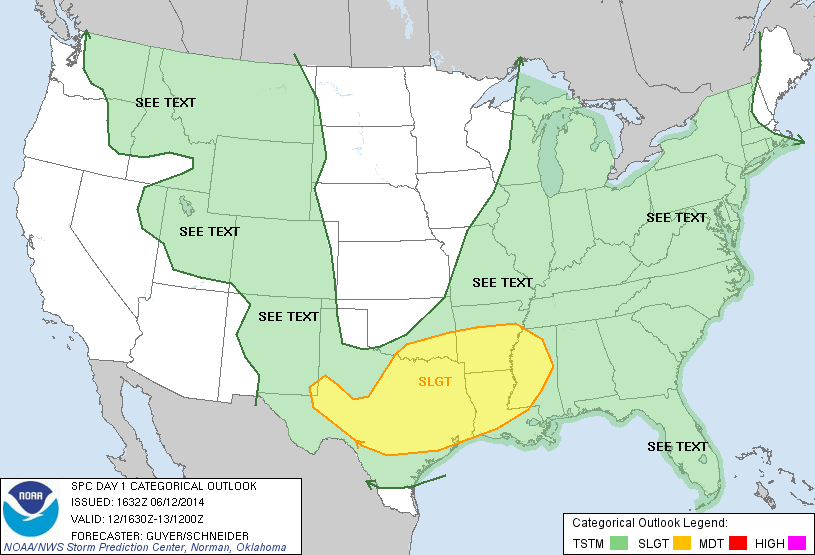
      Hey everybody, how's it going. Well I neee to inform you about some severe weather that could possibly be moving into the state today. Now The Storm Prediction Center (SPC) In Norman Oklahoma has issued a Slight Risk Area for Severe Weather. It outlines the Southern 1/3 of the State. Little Rock and Surrounding areas included. Here's a pic of the risk area. Now The risk is for Hail,  and possible damaging Thunderstorm winds. Strong to Severe Storms basically. Now the tornado threat is low. But it is Arkansas so nothing is impossible. Just to clarify, a risk area is NOT a Watch of any type. It just tells you what areas the Storm Prediction Center will be looking at for Severe Weather and what type of severe weather they're looking for. As always thank you guys for choosing me to be your go to guy for Weather Information. Yall have a Very good day.!

The 2014 Hurricane Season

Image
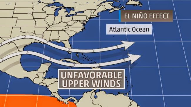
       Well Guys as of June 1 we have started our 2014 Hurricane Season. That means that this is the time of year that Hurricanes happen here in the United States (Atlantic Basin) the most.  So that beggs the question. What will this year's hurricane season be like? Well a few different Variables determine this.  In this years case what is called "El Ninio". El Ninio is basically a certain atmospheric setup that usually shreads the tops of the thunderstorms due to really strong crosswinds aloft. Here's a picture of El Ninio conditions.   Those Crosswinds is known as Windshear. That difference in the wind aloft is the number 1 killer of hurricanes. Hurricanes cannot have any resistance to properly form and develope. When you get Warm waters. No Windshear. And Room to roam. Then you've got a hurricane on your hands. If you're missing anyone of those variables then you can forget it. According to the Weather Channel and NOAAS's outlooks on the 201...

Flooding Concerns

        Hey Guys, How's it Going! I just wanted to update everybody and express my growing concerns regarding the Flooding potential we have. There's a lot of heavy rain developing in Oklahoma and Texas that will be moving into the state. These storms will be packing LOTS of heavy Rainfall with amounts being reaoly high in certain areas. This is a lot of rain at one time. These storms may be strong so the wind might push over lots of trees due to the soft ground. There may be more rain back building tonight and tomorrow to move across the state. There will be flash flooding in many spots. If you see water too deep, DO NOT try to cross it. It don't take much to pick your car up and potentially kill you. Save yourself by finding a alternate route. As always I appreciate you guys for following me and supporting me. I am Omarr Wilson The Arkansas Weather Hawk.

Welcome To The Arkansas Weather Hawk Blog

     Hey guys, how's it going. This is Omarr Wilson the Arkansas Weather Hawk. Welcome to the Weather Hawk's Blog. Im taking the way I get out Weather information and warnings out to a brand new level. Now I'm new to Blogging. So it'll take a while to work out the kinks. As always I appreciate everybody for choosing me to be your go to guy for Weather Information.