Busy Weather Schedule Ahead
Okay so I was planning on doing a weather update this morning, but I went straight to sleep after work. I'm glad I waited until the new evening runs of the models came in though. Well I have 3 Different systems to tell you guys about, and update you on. I'll try to shrink this as much as possible. I go in sequence of the weather systems.
Okay, so the first weather system is slated to move in during the morning hours on Thursday, then advance across the state throughout the day Thursday. Okay now this system carries no severe threat, no winter weather threat, and no flooding threat either. Moderate rain with this system at best, it will be moving at a fair speed, so there won't be much rainfall. There will be some, but not enough to add to flooding. This system is out by Thursday night.
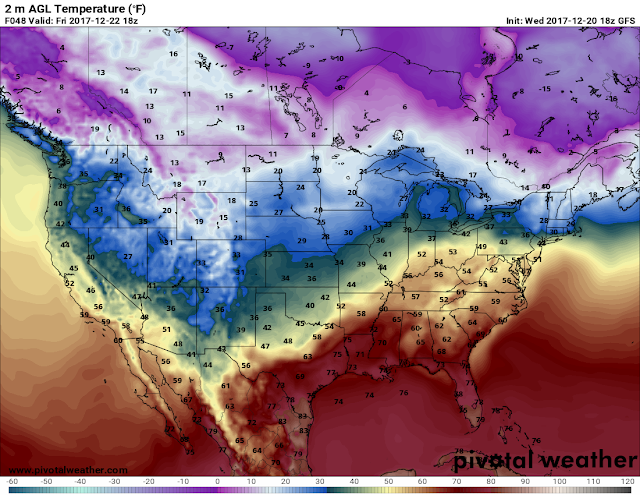
Okay now for the second system, this system was expected to come in during the morning and day time hours on Sunday. But after the latest model runs of the model data, it's now being projected to move through during the morning and daytime hours on Saturday. Now all three models, the GEM (Candian Weather Model), GFS (Global Forecasting System), and the NAM (North American Model) are projecting the same time periods with the difference of about an hour or two in the morning between the different models. NOW, the models project this to be out by Saturday Night HOWEVER, all three models pick up on wrap around moisture within the sub freezing Temperatures that will be moving in from the north behind the system on the backside of it. NONE of the weather models show anything to be particularly heavy. What this means is, there is a chance for snow flurries in the state overnight Saturday and around Midnight-3am Sunday Morning. Now in North Arkansas some areas could see possibly a light dusting. This is all gone by Sunday.
The Third system is due Late next week into next weekend. There lies a chance for moderate to heavy rain, with another shot at flurries or light snow on the backside of that system as well. It's a full week away, that can and will change in time.
Now the it's worth mentioning that the GEM weather model shows showers out ahead of the system coming in this weekend which means a chance of rain Friday. But it's the only model that show's that so I wouldn't bet on it.
So that's all that I have at this current time. If you have any questions about anything just comment, or message me, or whatever you want to do, and I'll be happy to answer. I appreciate you all for coming here to the blog. Have a GoodNight Everybody!
Follow Me On Social Media
TheArkansas WeatherHawk - Facebook
@OmarrWilson - Twitter
The Arkansas Weather Hawk - Google Plus


Comments
Post a Comment