Late Week Winter Weather!
GoodEvening everybody! I hope everybody has had a safe Morning, afternoon, and evening so far. We didn't have many accidents this morning because the rain stayed mostly rain, and the roadways weren't as slick as last time. Thank the Arkansas DOT for that! People were driving VERY SLOW this morning, that's an OCD for an impatient person, but it was good to see never the less. So out with the old, in with the new! More Snow, and Winter weather chances, Let's get into it!
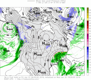
Okay so as far as timing goes, right now there's still some uncertainty within the models, but I'm thinking Thursday Night / Late Thursday Night / Friday Morning type stuff. Now how will this go down.... BY IN THE MORNING, or Midnight at least, the models should start to line up and give me a clearer picture on just how this will go down. I'm not seeing any correlation yet honestly..... These weather models got me confused, but in Weather Forecasting I've learned that you CANNOT base an entire forecast off of the weather models, they'll let you down.
So what are they saying? Okay well the GFS is still somewhat trending the same that it's been trending, but the changes are, the GFS brings rain in on Thursday, it's a cold rain, then a Change over up north where the Cold Air is. Then later on in the Night as the system pulls out of here as that air punch south a change over from rain, to freezing rain, to sleet, then finally all the way over to snow.... THAT WILL HAPPEN, now That I know for sure. Only I don't know where yet. Well I'm uncertain. Okay see the GFS has the Change over further EAST now, then the change over to all snow in East Arkansas all together, that takes Central Arkansas out of the Equation..... BUT this is ONLY a Forecast Model, I don't think this will happen in my mind. Now the NAM weather model show the same thing kind of, but in a different way. The NAM shows frozen Precipitation moving in at some point during the day Thursday, then after that, the main system misses the Entire State to the South and Only East Arkansas get clipped by the Back end of it, Giving East Arkansas the Only Snow chances on Friday. The EURO is showing a little more of what I think will happen. Rain throughout Thursday, Changing to Sleet, Changing to Snow on the backside of the system as it pulls away.... I don't know about the Canadian GEM (CMC) Weather Model bc it haven't updated yet... So as you all can see the weather models are doing a terrible job with this system. They are all over right now, it makes things very difficult to figure out. It's only Wednesday, we got a good 2 to possibly 3 runs to get a cleaner picture on things.

Okay here's the GFS (Global Forecasting System) Weather model, and as you can see it has moisture pushing into Central Arkansas, and what I'm thinking with this is that this entire area will be snow, or a Sleet/Snow Mix in areas, but I'm definitely thinking that this is frozen. And Often times with Weather Models, cold air is really dense and thick so they have a hard time measuring it, so they'll underestimate the speed of cold air. I think that's what the GFS is doing here. So I think this MAY be frozen by Midnight Friday Morning.

Then the GFS continues the Precipitation through the 3am hour on Friday Morning. At this point Im almost highly leaning to this being frozen by then. So if my prediction holds true, we are looking at what? 3-5 hours of consecutive snowfall, locally heavy in some spots okay.

Now as you can see here the GFS starts to back everything off here in Central Arkansas by 6am Friday morning as the system pulls away.

Now according to the GFS, East Arkansas will get Ice on top of the Likely Snow that has already fallen. This is according to ONE WEATHER MODEL!! And it's still Wednesday, so don't take this literally.

The NAM (North American Model) Misses Central Arkansas completely and only gives the frozen stuff to East Arkansas Early Friday morning..... See how out of control these models are!? They'll start to Line up throughout the morning and day tomorrow, I will keep you guys updated as they change!

National Weather Service has issued a Winter Weather ADVISORY For Pulaski County on EAST! And a Winter Storm Watch for the Entire East Side of Arkansas!
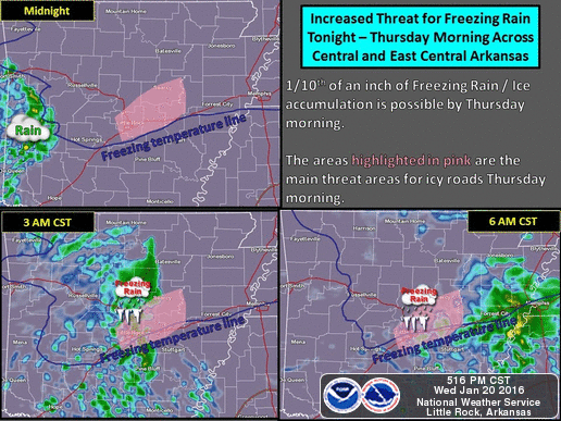
And Last, But CERTAINLY NOT LEAST, there will be Scattered Showers around tonight, and Tomorrow Morning... With Temperatures below freezing, that sets the stage for the DREADED FREEZING RAIN!! There is a Chance we could see at least a 10th of an inch Here In Central Arkansas! Let me tell you all something, if those roads are Frozen over, they WILL CANCEL SCHOOL here in Central Arkansas, so you kids need to watch the weather you may have a Snow day Coming! Parents plan accordingly! IF YOU HAVE TO DRIVE IN THE MORNING, OR FRIDAY MORNING... THIS IS DANGEROUS WEATHER, USE EXTREME CAUTION, AND DRIVE SLOW!! I don't want nobody dying out there!
I know this was a long weather update and that was a lot of reading, if you made all the way down here I'm sorry! Lol it's a lot of info but I HAVE to get this information out. I will continue to stay on top of things from Central Intelligence, make sure you share this. Feel free to ask me any questions you may have. I appreciate. Everybody's support and thanks for coming here to the Weather Hawk's Blog.
Follow Me On Social Media
TheArkansas WeatherHawk - Facebook
@OmarrWilson - Twitter
The Arkansas Weather Hawk - Google Plus


Thanks for your hard work in updating us!
ReplyDeleteAppreciate all your hard work!!
ReplyDelete