Snow Storm Or Not????
GoodMorning Everybody!! I know Everybody's been really waiting on this Weather Update so I'm diving right in! Okay so as far as timing goes, all of the Models agree on Overnight tonight, and into tomorrow morning! They ALL agree on that!
Okay so as far as the Weather Models themselves, they are starting to Line Up!! On my Last Weather Update I told you guys that they will line up within the next couple of runs, and they did! The NAM (North American Model) shifted the track of the Low Pressure System closer to East Arkansas and REALLY POURED on the Snow for Central Arkansas! Now With that said, it's ONLY A FORECAST MODEL, IT MAY OR MAY NOT VERIFY. And East Arkansas is still the area that has the Best chance for the highest Snow Accumulations. The GFS (Global Forecasting System) Weather Model has the Low Pressure system staying in it's original projected track keeping East Arkansas with the absolute highest Totals, and Us here in Central not getting so much or as much. So we got two well respected models saying two different things, this all matters when it comes to accumulations, if the NAM verify then it's More Snow.... If The GFS verify, then that's more snow for East Arkansas..Which one will win? Type stuff.
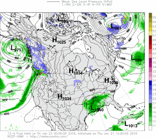


Okay so as far as the Weather Models themselves, they are starting to Line Up!! On my Last Weather Update I told you guys that they will line up within the next couple of runs, and they did! The NAM (North American Model) shifted the track of the Low Pressure System closer to East Arkansas and REALLY POURED on the Snow for Central Arkansas! Now With that said, it's ONLY A FORECAST MODEL, IT MAY OR MAY NOT VERIFY. And East Arkansas is still the area that has the Best chance for the highest Snow Accumulations. The GFS (Global Forecasting System) Weather Model has the Low Pressure system staying in it's original projected track keeping East Arkansas with the absolute highest Totals, and Us here in Central not getting so much or as much. So we got two well respected models saying two different things, this all matters when it comes to accumulations, if the NAM verify then it's More Snow.... If The GFS verify, then that's more snow for East Arkansas..Which one will win? Type stuff.

Here's the NAM (North American Model) by 12am midnight tonight, those precips out here is frozen likely, so right there you're looking at pure snow fall.

Here's the NAM by 6am Friday Morning, it's finally showing the change over, we are going to look over that. Weather Models are horrible with measuring the speed of Cold air. It will have been snowing during that entire period sense midnight. But look at the amount of Precipitation still around Central Arkansas within that 6 hour period.

Now within the hours of 6am and 12noon you can see the NAM shows the Low pulling away yet STILL dropping snow over Central Arkansas.... See what we have here!? A consecutive 5-6hours of Solid Snow fall! That's enough to get some good totals! 4inches, maybe more in certain areas! This is just according to the NAM! Below is the GFS!

Okay here's the GFS (Global Forecasting System) weather model. This model shows an intense band of precipitation in Central Arkansas. Again, at this point this is likely snow. By the time this gets here the temperature should be below or right at freezing. So if it's not changing over, it's ALREADY changed over!

Now here's the GFS in between 6am and 12noon on tomorrow, it show's the same thing as the NAM, but the major difference here is that the GFS is not as Intense with the Snowfall on the back side of this system. That's because the GFS has the Low Pressure system in a different Location. So this is a matter of, which Model will Verify?! Personally I HOPE THE NAM VERIFY!

This Map is Courtesy of the National Weather Service here in North Little Rock. Their expectations is siding with the NAM weather model. They are siding with the Track of the system that the NAM shows. Then that heavy band of precipitation that the GFS shows is further south here across Central Arkansas. That brings us a heavy band of numerours consecutive hours of Moderate-Heavy Snowfall. That's good to give us totals of up to 4inches of snow right here in Central Arkansas. This is just an ESTIMATE, we MAY receive MORE OR LESS snow than predicted. Isolated Areas could see higher amounts! Now this is actually the general forecast of the EUROPEAN Weather Model. So Let's pray this Verify.

Since we are expecting a major winter storm at this time, a WINTER STORM WARNING has been issued by the National Weather Service due to the anticipation of heavy Winter Weather!
So here's the number 1 question... Do I need to Batton Down the Hatchets??? I say Based off of what I see and the Models, coupled with the Possibility of what Could Happen, YES!!! Go for the Bread Isle, get your butter, Rice, Chili, and Soup!! Most of all, GRAB YOUR HOT CHOCOLATE!
I want to thank everybody for coming here to the Arkansas Weather Hawk's Blog! I'm finally at home so I'll do another update in about 6 hours to let you guys know of any changes!
Follow Me On Social Media!
TheArkansas WeatherHawk - Facebook
@OmarrWilson - Twitter
The Arkansas Weather Hawk - Google Plus


Comments
Post a Comment