Posts

Developing: Severe Weather Possible

Image
        Hey Everybody, How's it going. I hope all is well at this point, and GoodMorning to All. There is a chance for Damaging wind today, and some Large Hail. There will be a Slight Tornado Threat with this, but I do not expect anytype of major weather Outbreak.         The Chance is Definitely there for Strong Damaging Wind with this, as well as the possibility for Some Strong hail. There will be a Squall Line moving in over the course of the Morning through West, and West Central Arkansas. This will ramp this afternoon as the atmosphere heat up. By the time the atmosphere get to a point to where it can support Elevated thunderstorms. Now with this threat of Elevated storms, this will be in West Central Arkansas moving into the Central Sections of the State. The Line of Storms will intensify as it draws deeper into Central Arkansas, and into and through East Arkansas.        There is an Isolated Tornado threat just due ...

Developing: More Bad Weather Coming

Image
          Hey everybody, I hope all is well. Thankfully the More Recent Tornadoes we have had has not caused any damage other than crop damage. Those are the reports I enjoy reading. The only thing is, we have been getting this lucky because so far everybody has been paying attention to Weather Warnings, and taking them seriously. I also have to give Credit to The Arkansas Storm Team, and KATV 7 for their amazing coverage over the past several events. These News Agencies have been coordinating at record Levels with Storm Chasers in the field getting accurate accounts for everything that's going on, and they have done a great job at getting that out over the air to the public. The National Weather Service has done a Great Job at Their accuracy forecasting upcoming Severe Weather Events, and getting those warnings posted as soon as they detect dangerous weather, I Love it when Broadcast Media, and Meteorology work hand in hand, and save lives....... Now, on to the...

⚠️DEVELOPING⚠️ WEDNESDAY TROUBLE

Image
        Hey GoodMorning Everybody. This is a very Serious Severe Weather Situation developing right now over the State Of Arkansas. I don't want to waste any time on this, so Let's get directly to the point. This is a Risk Map from The Storm Prediction Center in Norman Oklahoma. They have issued a Slight, Enhanced, and Moderate Risk for Severe Weather in the State of Arkansas. Let's talk about what this means. So There's a Slight Risk for Severe Weather in West Arkansas. Means that in that area, you MAY OR MAY NOT see Severe Weather. There is an Enhanced Risk For Severe Weather in the East 1/2 of Arkansas, what that means is You Will see Severe Weather, and there is an ELEVATED chance that it will get REALLY bad if You live in the Orange Shaded Area. Then From Little Rock, on to the East all the way to the Mississippi River, there is a DEFINITE Chance that you WILL Experience some Severe Weather, and you may see Some Large Tornadoes.  ALL MODES of Severe Weather...

SEVERE WEATHER UPDATE: What's Next?

Image
         Hey GoodMorning Everybody, l seriously hope everybody is okay after Yesterday's Storms, and Tornadoes. Yesterday was very crazy, we did expect some Tornadoes in Places, and if You Read my Last Severe Weather Update that I did Yesterday Morning, I did say That I Did Expect a Widespread Outbreak of Severe Weather. Unfortunately I was right, and we did experience Widespread Severe Weather. Those Tornadoes came up Fast, they got organized, and they did pose some serious threats to human Life. Look, when Forecasters, and Meteorologist post Weather Updates telling you to be alert, and Pay attention, It's FOR A REASON. People not just typing this stuff for fun. This is Spring in Arkansas, it is NOT A GAME. Tornadoes are serious business, and they will come out of nowhere, you really have to pay attention to what's going on around you.          So, For today, let's just cut to the chase. I do not expect widespread Tornadoes today, but t...

DEVELOPING STORY: Serious Weather Coming

Image
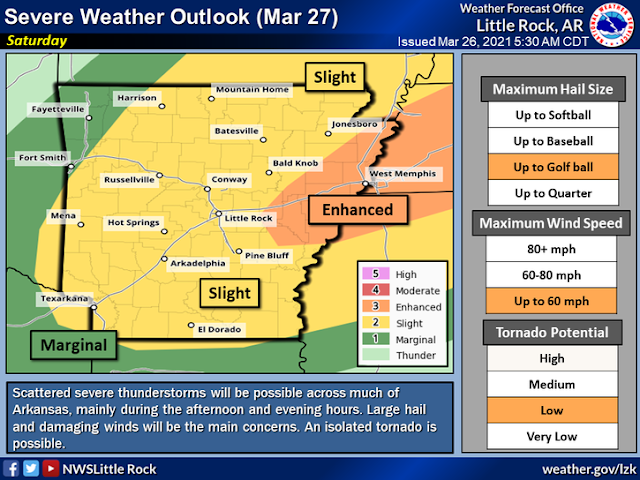
       Hey everybody, GoodMorning! I'm sure most of you know by now if you watch the news that we have several rounds of very serious weather moving in over the next 3 days. Now here's the deal, it's APRIL, and Spring, in the State of Arkanado.... This is NOT the time to brush off life threatening weather. Tornadoes are a Serious threat to YOUR life.        Now Monday, everything will start as it should. Very windy, and warm. But as we work through the Afternoon - Evening hours, Strong to Severe Storm will start to develop in Southwest, and West Arkansas. These Storms will move to the East into the night-time and Evening hours and they will pose a SERIOUS threat to human life in Central, and East Arkansas as we go along. I expect a Tornado Watch for a major part of Arkansas tomorrow afternoon. Check the image below.  This is a Risk Forecast map of Monday from the National Weather Service in North Little Rock. The main threats with this will b...

DEVELOPING: Windy Wednesday

Image
        Hey Everybody, good Afternoon. This update is to make Everybody aware of an increasing threat of Severe Weather across the State tomorrow morning, and Afternoon. It is Spring time in Arkansas, we all know about Tornadoes, how fast they happen, and how bad things can get. Weather around here can go Mild to Wild Reach quick. Springbreak is over, which means school is back in session, I think School Admins, Kids, and Teachers in Central, and East Arkansas need to be on Standby tomorrow morning from about 9am throughout the rest of the day for bad weather.          So the Main Threats is Wind, and Isolated Tornadoes. Problem is this is a LOT of wind energy with this system, so with that always brings an elevated threat for Tornadoes. This is a New Risk map from the National Weather Service in North Little Rock. There is an Enhanced Threat for Severe Weather for the East 1/2 of Arkansas, this does include the Little Rock Metropolitan and a...

DEVELOPING: Snow To Storms‼️

Image
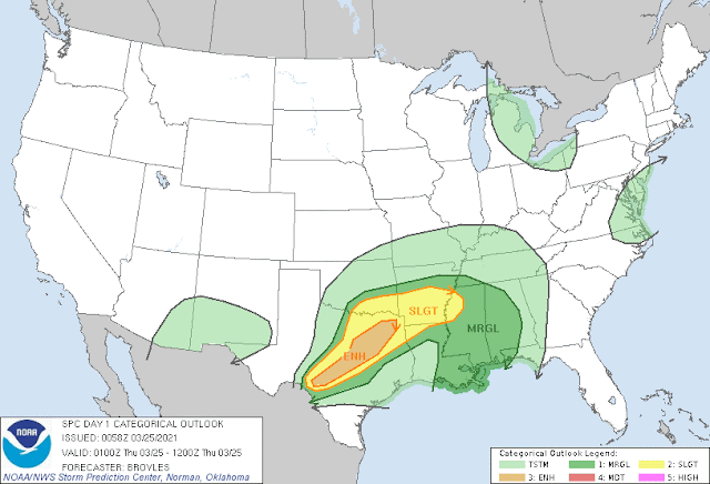
              Hey everybody, how's it going! Last update was about Winter Weather. Now let's talk about a chance for Severe Weather. I have a feeling that pretty soon, we'll be talking about Winter Weather again. Winter, Spring, Winter in the Same Month...... THIS IS HOW YOU ARKANSAS!        Our chance for Severe Weather is Wednesday (Tomorrow), and Thursday. At this point as far as Timing, the weather models are hinting at Overnight Wednesday and into Thursday morning. Thursday morning is looking like the more probable timing for any severe weather we have. There is a possibility for some scattered spinup tornadoes at this point. This is the National Weather Service map for Wednesday Night. The Storm Prediction Center in Norman Oklahoma, has issued a Slight Risk Severe Weather for the West 1/2 of the State. This threat will transition east into Thursday Morning.  This is the Severe Weather Risk into Thursday Morning as the Sev...

DEVELOPING: New Winter Weather Guidance

Image
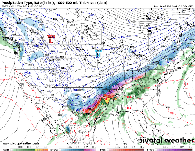
      GoodMorning Everybody, how's it going! Today is Wednesday February 2nd, 2022. I did a weather update yesterday morning about an incoming High Impact Winter Storm that we have moving into the State of Arkansas. Over the past 24 hours we've gotten new model guidance on this storm and it's possible impacts to the State of Arkansas, and what's expected to setup, and where, and how much. There hasn't been many changes, but there has been a few.       Okay so between yesterday, and today the changes as far as model guidance goes, the European Weather Model has now started to line up with the GFS (Global Forecasting System), and the NAM (North American Model). We're starting to get lot's of model consistency as far as the Models showing the same thing from Run to Run. The NAM is warmer than the GFS, Meaning the NAM is holding off the Below freezing Temperatures until Thursday morning, which if THAT verify, then we wouldn't have as much Freezing Rain as ex...

DEVELOPING: 2022 High Impact Winter Storm

Image
      Hey Everybody, how you doing!? Today it is Tuesday, February 1rst, 2022 at 11am in the morning. Since January 28th Weather Forecasters across the country have had their eyes on a Winter storm in the making. Now the Weather Forecast have flip flopped more than the president. But as of Yesterday we're starting to get some model consistency painting a more clear picture of how this stuff will play out, and I must say, it doesn't look good at all.       So of course it was Warm across Arkansas Monday the 31rst, and will be warm through today, and most of tomorrow. With temperatures being that warm, the ground my retain most of that heat, and this will cause the frozen precipitation to not stick on most roadways with the exception of bridges and overpasses. This is my initial thoughts. But this changes after the temperatures drop down to 28° which is what these models are projecting. When the OUTSIDE AIR TEMPERATURES get down that low, everything starts to...

Forecasting The Weather

       Hey Everybody, My name is Omarrian Wilson. Professionally, I'm known as "The Arkansas Weather Hawk." I've been Chasing Tornadoes for Many years, I've been forecasting the Weather since Highschool. Weather Forecasting is a Very complex set of procedures, and the art of forecasting severe weather to any degree of accuracy requires distinct knowledge of weather statistics, atmospheric dynamics, and a unique interpretation of what it is you're looking at when you look at weather maps, and graphics, and weather data collectively. In this article, I will breakdown what goes into a weather forecast, and how Meteorologist can predict historic weather outbreaks like the outbreak of December 10th, 2021.        So, a basic forecast of any weather anomaly (Event), will start with a look, or a breakdown of a weather model, or a set of weather models. The National Weather Service release Weather Balloons into the atmosphere several times each day, in mul...

Developing Severe Weather Update

Image
        Hey Everybody, Good Afternoon on this Lovely Saturday! It definitely feels great out there, it was a really nice Morning here in Little Rock. But unfortunately that Nice Weather will give way to some pretty mean storms that are expected to develop over the Next Several hours here across the State. Let's talk about it. So Storm Prediction Center in Norman Oklahoma has pushed the "Enhanced Risk" for Severe Weather further to the West to Include Central Sections of the State. This is an update from last night, which just included East Arkansas near the Mississippi Delta. Now the Mississippi Delta, and Points further to the West are Included. This does involve Little Rock, and most Surrounding Areas. Now it's worth Noting here that the Main Threats to look for will definitely be Damaging Straight Lined Winds, and Large Hail, but there is a Tornado Threat. The Tornado Threat is Fairly Low, but it's present due to the amount of Wind Energy associated with this S...

Severe Weather Update: Sketchy Weather Saturday

Image
        Hey Everybody how's it going!? I hope everybody is safe, enjoying this beautiful spring weather. Speaking of the Weather, we have more severe weather coming in. There is a Chance for more Severe Weather Saturday Night in the State associated with a Front moving through, there will be a lot of wind energy associated with this front. This system won't have a particularly high amount of Instability with it, but it will be a lot of Wind Shear (The Turning of Wind with Height). So even in a Night-time environment, Storms will still have the ability to develop and rapidly become severe.  Storm Prediction Center in Norman Oklahoma, has already issued a Slight Risk area for majority of the State with an Enhanced Risk for East Arkansas. An Enhanced Risk is an area of heightened concern within a general area.         The Main Threats here are Wind, and Hail, the Risk for Tornadoes is Definitely there, but I don't expect a Major Outbreak of...

Severe Weather Update: Mild To Wild

Image
        Hey Good Evening Everybody! I hope all is well, and everybody is staying safe. This will be the Second, and Third Severe Weather Setups of the Season here in the Mid-south for Spring Tornado Season 2021, it's not looking as potent, and intense as the Last one. But however, there are some definite Severe Weather possibilities with these next two setups.         Setup Number One is scheduled to arrive Later tonight, into Tomorrow morning. When I say "Tomorrow Morning" I mean between 3-8am in the morning, with this first round of storms, there's more of a Wind, and Hail Threat then a Tornado Threat due to the Timing of the system. I don't expect too Much in the way of Tornadoes, although some could be Possible. But Storm Prediction Center in Norman Oklahoma has outlined a Slight Risk for Severe Weather Overnight into the early morning hours Tomorrow for Southwest, and Central Arkansas.  As you can see Here, Slight Risk area for Seve...

⚠️SEVERE WEATHER UPDATE⚠️ Wicked Wednesday‼️

Image
        Hey Everybody, I hope all is great! Time to Change Gears here on the Blog, from Winter to Spring, from Snowmageddon to the ThunderDome! There is a Chance, our First Legit Chance for Severe Weather and Tornadoes here in Arkansas. There was somewhat of a chance this past Sunday (March 14th, 2021), but with evaporative cooling taking place over Arkansas, storms stayed Below Severe Limits with no Severe Storms. But however, this coming Storm System moving into Arkansas by Wednesday will be a lot more potent, and unstable. Due to the amount of Instability accompanied with this system, it has raised some obvious concerns for Severe Weather in the State. So Let's dig in.        While the Weather has been quite pleasant as we have shifted from Winter to Spring here in Arkansas, that comes at a price..... The Price we Pay is our Primary Storm Season, it's really starting to ramp up across Arkansas this week with one major chance at some pretty stro...

Winter Weather Update: Arkanrado Snowmageddon

Image
       Hey Everybody, I hope all have been safe during this Polar Express. I know some people "Have No Choice" but to drive to work regardless of the weather, which I think is ridiculous, because risking your life is always a choice... But However, in the Process of making it to work, I Hope and Pray that Everybody is safe and Sound, and Unharmed. I have seen lots of Video's on Social Media of people Speeding down the highway...... That's how Car Crashes happen, that's how Lives are Lost. SLOW DOWN ON THOSE ROADS! Your Jobs are Not going to go anywhere, nor is speeding in the Snow going to get you there any quicker. So SLOW DOWN ON THOSE ROADS.         Now On to Round #2! But before that, Areas around Central Arkansas and Points to the West and South got Big time Snow totals, that just goes to show you that Regardless of how accurate we try to make forecast, they are not perfect, and wherever the Snow Bands setup are pretty random. Weather Mo...

Winter Weather Update: New Model Guidance!!! More Snow!!

Image
        Hey Everybody, I hope you all have everything you need for the next several days because we are on track to get way more snow than we have! As of right now, making this post, I measured 1" of Snow outside my house here in West Little Rock. Now, there has been some updated images from 2 different models that I tend to study very closely. The GFS (Global Forecasting System) Weather Model is sticking to the original idea of all the heavier totals being confined to Southeast Arkansas. But Models like the NAM (North American Model), and HRRR (High Resolution Rapid Refresh) models are bringing higher totals back up into Central Arkansas. Check Below. This is the NAM (North American Model), this is Valid out to Midnight Overnight tonight, this shows a Second Band of Snow Moving up the I-30 Corridor and into Central Arkansas. Some of these Convective Bands of Snow could be Moderate to Heavy in intensity.  This is the NAM in between the Hours of 3am and 6am tomor...

Valentine's Day Eve 2021 Winter Weather Update

Image
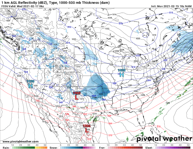
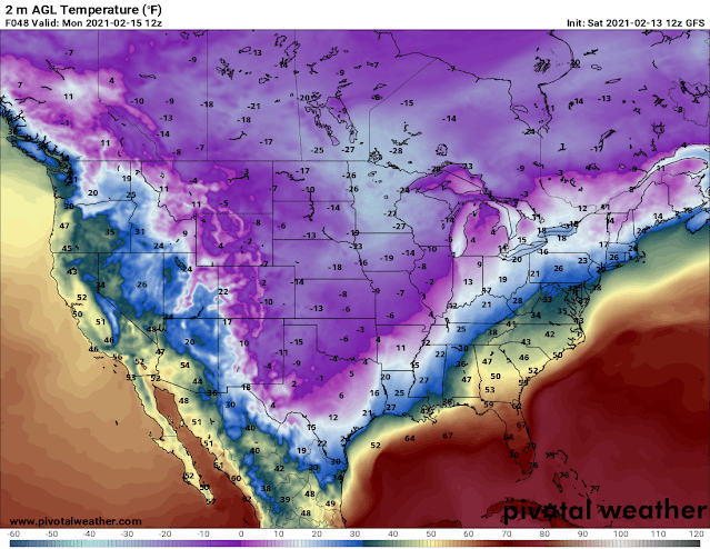
        Hey Everybody! Happy Valentine's Day Eve 2021! I have a Feeling I'll be doing another Update tomorrow about this storm. But since the Very Basics of the Storm was Covered in the Last Update, I will only go over the Changes between Yesterday and Today in this one, that way I'm not repeating myself. If you haven't seen the Last Update "Winter Weather Update: ANTARCTIC Express???," You should DEFINITELY check it out for sure! Like I said, not much has changed, the Models are disagreeing about the Onset of when everything Starts, they're also disagreeing with intensity, and exactly where the Snow Bands setup, which is typical, they usually don't agree until the day of, then they'll line up.  They also don't agree with Temperatures. The NAM (North American Model) is warmer on Tuesday Morning than the GFS (Global Forecasting System), and the EURO (European Weather Model).  This is the GFS surface Temperature Map, this has us at 11° here in Ce...

Winter Weather Update: ANTARCTIC Express???

Image
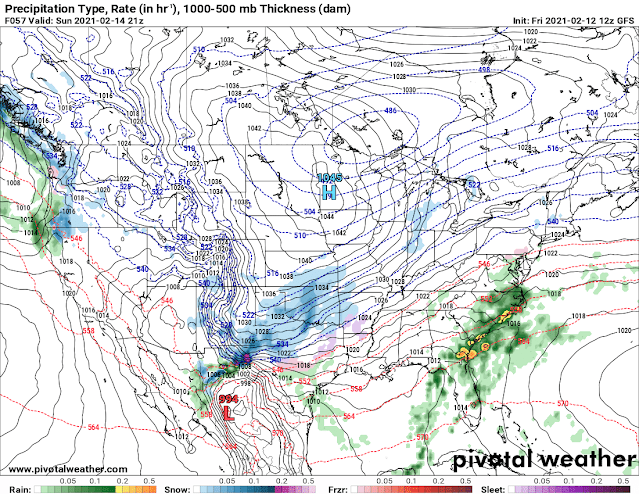
         Hey everybody, how's it going everybody? I hope Everybody is remaining warm, and safe today. Most of the Ice from Yesterday's Storm is gone, but however we have more winter Weather coming, TO SAY THE LEAST!!!! I have never seen Subzero Temperatures here in Arkansas in my 28 year old life.... Not that I can remember  anyways. But It's looking like a true possibility here in Arkansas, and Central Arkansas. Let's just get right too this.         Now as far as Sunday goes, what's New? Well Both the NAM, and GFS Models wants to bring in an early Wave of Precipitation on Sunday Morning, and afternoon. The GFS has everything very scattered with Majority of the Precipitation in West Arkansas up until Sunday Night, into Monday Morning. The NAM wants to bring an entire Wave of Moisture through on Sunday Afternoon, then another wave overnight Sunday and Into Monday Lasting through Monday Afternoon before getting out of here.  This is ...